Lutuhyne geodata
Lutuhyne (Luhansk) is a seat of a second-order administrative division; located in Ukraine in Europe/Zaporozhye (GMT+3) time zone. With population of 18,830 people, there are 213 cities with bigger population in this country. Compared to other cities in Ukraine, 52.9% of cities are located further ↓South; 98.9% of cities are located further ←West and 55.4% of cities have higher elevation than Lutuhyne. Note1


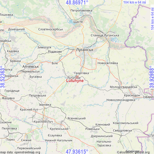
Lutuhyne GPS coordinates[2]
48° 24' 18.252" North, 39° 13' 36.3" East
| Map corner | latitude | longitude |
|---|---|---|
| Upper-left | 48.86971°, | 38.52363° |
| Center: | 48.40507°, | 39.22675° |
| Lower-right: | 47.93615°, | 39.92988° |
| Map W x H: | 103.8×103.8 km | = 64.5×64.5mi |
| max Lat: | 52.18903° ⇑47.1% North |
| Lutuhyne: | 48.40507° |
| min Lat: | ⇓52.9% South 44.39214° |
| min Long | Lutuhyne | max Long |
| 22.20555° | 39.22675° | 40.13222° |
| W 98.9%⇐ | ⇒1.1% E |
Elevation
Elevation of Lutuhyne is 119 m = 390 ft, and this is 36.8 m = 121 ft below average elevation for this country.
| Max E: |
886 m = 2907 ft | 55.4% |
| Avg. | 155.8 m = 511 ft | |
| Lutuhyne | 119 m = 390 ft | |
Min E: |
-3 m = -10 ft | 44.6% |
See also: Ukraine elevation on elevation.city.
Geographical zone
Lutuhyne is located in North temperate zone (between Tropic of Cancer and the Arctic Circle). Distance of this North polar circle is 2019 km =1254.5 mi to North.| Distance of | km | miles | from Lutuhyne |
|---|---|---|---|
| North Pole | 4624.9 | 2873.8 | to North |
| Arctic Circle | 2019 | 1254.5 | to North |
| Tropic Cancer | 2776.2 | 1725.1 | to South |
| Equator | 5382.1 | 3344.3 | to South |


Nearby cities:
15 places around Lutuhyne: (largest is in red/bold)
• Alchevs’k
31.1 km =19.3 mi,  283°
283°
• Antratsyt
33.8 km =21 mi,  197°
197°
• Bile
16.4 km =10.2 mi,  307°
307°
• Buran
31 km =19.3 mi,  112°
112°
• Lenina
6.6 km =4.1 mi,  294°
294°
• Luhansk
19.2 km =11.9 mi,  20°
20°
• Millerovo
26.7 km =16.6 mi,  189°
189°
• Molodohvardiys’k
32.1 km =19.9 mi,  101°
101°
• Pereval’s’k
28.5 km =17.7 mi, 277°
• Rozkishne
10.2 km =6.3 mi, 22°
• Simeykyne
24.3 km =15.1 mi, 111°
• Stanytsya Luhans’ka
33.4 km =20.8 mi,  33°
33°
• Teple
26.9 km =16.7 mi, 112°
• Uspenka
5 km =3.1 mi,  251°
251°
• Zymohiria
29.3 km =18.2 mi, 313°
In other languages:
- In Spanish: Lutúgine
- In France: Loutouhyne
- In Russian: Лутугино
- In Chinese: 盧圖吉諾
Sources, notices
• [Note1] Compared only with cities in Ukraine existing in our database
• [Src1] Map data: © OpenStreetMap contributors (CC-BY-SA)
• [Src2] Other city data from geonames.org with taken over terms of usage.
• [Src3] Geographical zone / Annual Mean Temperature by Robert A. Rohde @ Wikipedia
