Ratne geodata
Ratne (Volyn) is a seat of a second-order administrative division; located in Ukraine in Europe/Kiev (GMT+3) time zone. With population of 9,081 people, there are 396 cities with bigger population in this country. Compared to other cities in Ukraine, 98.8% of cities are located further ↓South; 89.2% of cities are located further →East and 56.3% of cities have lower elevation than Ratne. Note1


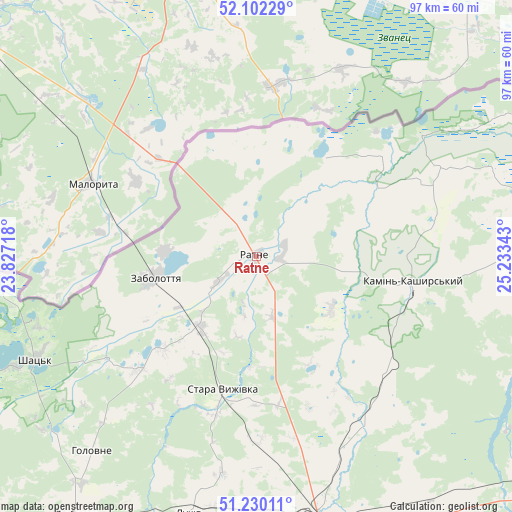
Ratne GPS coordinates[2]
51° 40' 5.88" North, 24° 31' 49.08" East
| Map corner | latitude | longitude |
|---|---|---|
| Upper-left | 52.10229°, | 23.82718° |
| Center: | 51.6683°, | 24.5303° |
| Lower-right: | 51.23011°, | 25.23343° |
| Map W x H: | 97×97 km | = 60.3×60.3mi |
| max Lat: | 52.18903° ⇑1.2% North |
| Ratne: | 51.6683° |
| min Lat: | ⇓98.8% South 44.39214° |
| min Long | Ratne | max Long |
| 22.20555° | 24.5303° | 40.13222° |
| W 10.8%⇐ | ⇒89.2% E |
Elevation
Elevation of Ratne is 156 m = 512 ft, and this is 0.19999999999999 m = 1 ft above average elevation for this country.
| Max E: |
886 m = 2907 ft | 43.7% |
| Ratne | 156 m 512 ft | |
| Avg. | 155.8 m = 511 ft | |
Min E: |
-3 m = -10 ft | 56.3% |
See also: Ukraine elevation on elevation.city.
Geographical zone
Ratne is located in North temperate zone (between Tropic of Cancer and the Arctic Circle). Distance of this North polar circle is 1656.2 km =1029.1 mi to North.| Distance of | km | miles | from Ratne |
|---|---|---|---|
| North Pole | 4262.1 | 2648.3 | to North |
| Arctic Circle | 1656.2 | 1029.1 | to North |
| Tropic Cancer | 3139.1 | 1950.5 | to South |
| Equator | 5745 | 3569.8 | to South |


Nearby cities:
15 places around Ratne: (largest is in red/bold)
• Hołoby
72.7 km =45.2 mi,  152°
152°
• Kamin-Kashyrskyi
30 km =18.6 mi,  99°
99°
• Kovel
51.9 km =32.2 mi,  166°
166°
• Liuboml
59.9 km =37.2 mi,  214°
214°
• Lyubeshiv
68.6 km =42.6 mi,  80°
80°
• Manevychi
81 km =50.3 mi,  120°
120°
• Nuyno
29.5 km =18.3 mi, 117°
• Oles’k
66.4 km =41.3 mi,  200°
200°
• Pidrichchya
20.7 km =12.9 mi, 116°
• Pishcha
49.4 km =30.7 mi,  262°
262°
• Rakiv Lis
27.7 km =17.2 mi, 100°
• Shats’k
44.9 km =27.9 mi,  245°
245°
• Stara Vyzhivka
26.4 km =16.4 mi,  193°
193°
• Svityaz’
50.8 km =31.6 mi, 245°
• Turiys’k
64.7 km =40.2 mi,  180°
180°
Sources, notices
• [Note1] Compared only with cities in Ukraine existing in our database
• [Src1] Map data: © OpenStreetMap contributors (CC-BY-SA)
• [Src2] Other city data from geonames.org with taken over terms of usage.
• [Src3] Geographical zone / Annual Mean Temperature by Robert A. Rohde @ Wikipedia
