Knyazhichi geodata
Knyazhichi (Kyiv) is a populated place; located in Ukraine in Europe/Kiev (GMT+3) time zone. With population of 5,207 people, there are 631 cities with bigger population in this country. Compared to other cities in Ukraine, 90.2% of cities are located further ↓South; 62.9% of cities are located further →East and 58.5% of cities have higher elevation than Knyazhichi. Note1


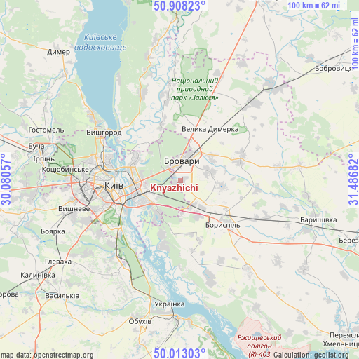
Knyazhichi GPS coordinates[2]
50° 27' 45.9" North, 30° 47' 1.284" East
| Map corner | latitude | longitude |
|---|---|---|
| Upper-left | 50.90823°, | 30.08057° |
| Center: | 50.46275°, | 30.78369° |
| Lower-right: | 50.01303°, | 31.48682° |
| Map W x H: | 99.5×99.5 km | = 61.8×61.8mi |
| max Lat: | 52.18903° ⇑9.8% North |
| Knyazhichi: | 50.46275° |
| min Lat: | ⇓90.2% South 44.39214° |
| min Long | Knyazhichi | max Long |
| 22.20555° | 30.78369° | 40.13222° |
| W 37.1%⇐ | ⇒62.9% E |
Elevation
Elevation of Knyazhichi is 111 m = 364 ft, and this is 44.8 m = 147 ft below average elevation for this country.
| Max E: |
886 m = 2907 ft | 58.5% |
| Avg. | 155.8 m = 511 ft | |
| Knyazhichi | 111 m = 364 ft | |
Min E: |
-3 m = -10 ft | 41.5% |
See also: Ukraine elevation on elevation.city.
Geographical zone
Knyazhichi is located in North temperate zone (between Tropic of Cancer and the Arctic Circle). Distance of this North polar circle is 1790.2 km =1112.4 mi to North.| Distance of | km | miles | from Knyazhichi |
|---|---|---|---|
| North Pole | 4396.1 | 2731.6 | to North |
| Arctic Circle | 1790.2 | 1112.4 | to North |
| Tropic Cancer | 3005 | 1867.2 | to South |
| Equator | 5610.9 | 3486.5 | to South |


Nearby cities:
15 places around Knyazhichi: (largest is in red/bold)
• Boryspil’
17.2 km =10.7 mi,  135°
135°
• Brovary
6.4 km =4 mi,  14°
14°
• Chabany
28.9 km =18 mi,  242°
242°
• Hnidyn
15.7 km =9.8 mi,  199°
199°
• Khotiv
26.7 km =16.6 mi, 236°
• Khotyanivka
21.2 km =13.2 mi,  314°
314°
• Kirove
26.1 km =16.2 mi,  113°
113°
• Kyiv
18.4 km =11.4 mi,  267°
267°
• Pohreby
14.2 km =8.8 mi,  316°
316°
• Prolisky
8 km =5 mi,  181°
181°
• Pukhivka
17 km =10.6 mi,  344°
344°
• Trebukhiv
8.8 km =5.5 mi,  74°
74°
• Velyka Dymerka
16.8 km =10.4 mi,  30°
30°
• Voronkov
28 km =17.4 mi,  162°
162°
• Vyshhorod
24.8 km =15.4 mi,  303°
303°
Sources, notices
• [Note1] Compared only with cities in Ukraine existing in our database
• [Src1] Map data: © OpenStreetMap contributors (CC-BY-SA)
• [Src2] Other city data from geonames.org with taken over terms of usage.
• [Src3] Geographical zone / Annual Mean Temperature by Robert A. Rohde @ Wikipedia
