Trebukhiv geodata
Trebukhiv (Kyiv) is a populated place; located in Ukraine in Europe/Kiev (GMT+3) time zone. With population of 6,207 people, there are 558 cities with bigger population in this country. Compared to other cities in Ukraine, 90.6% of cities are located further ↓South; 61.9% of cities are located further →East and 57.4% of cities have higher elevation than Trebukhiv. Note1


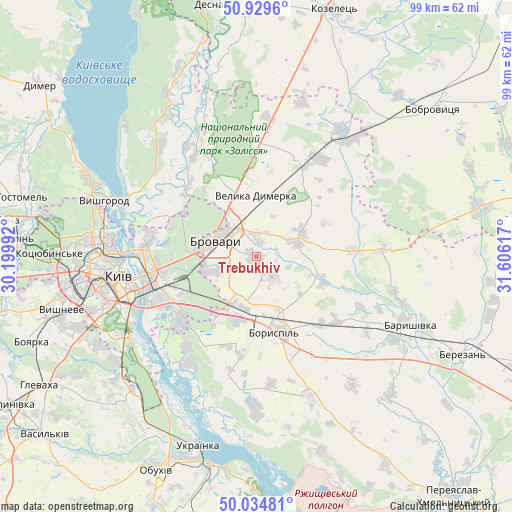
Trebukhiv GPS coordinates[2]
50° 29' 3.552" North, 30° 54' 10.944" East
| Map corner | latitude | longitude |
|---|---|---|
| Upper-left | 50.9296°, | 30.19992° |
| Center: | 50.48432°, | 30.90304° |
| Lower-right: | 50.03481°, | 31.60617° |
| Map W x H: | 99.5×99.5 km | = 61.8×61.8mi |
| max Lat: | 52.18903° ⇑9.4% North |
| Trebukhiv: | 50.48432° |
| min Lat: | ⇓90.6% South 44.39214° |
| min Long | Trebukhiv | max Long |
| 22.20555° | 30.90304° | 40.13222° |
| W 38.1%⇐ | ⇒61.9% E |
Elevation
Elevation of Trebukhiv is 114 m = 374 ft, and this is 41.8 m = 137 ft below average elevation for this country.
| Max E: |
886 m = 2907 ft | 57.4% |
| Avg. | 155.8 m = 511 ft | |
| Trebukhiv | 114 m = 374 ft | |
Min E: |
-3 m = -10 ft | 42.6% |
See also: Ukraine elevation on elevation.city.
Geographical zone
Trebukhiv is located in North temperate zone (between Tropic of Cancer and the Arctic Circle). Distance of this North polar circle is 1787.8 km =1110.9 mi to North.| Distance of | km | miles | from Trebukhiv |
|---|---|---|---|
| North Pole | 4393.7 | 2730.1 | to North |
| Arctic Circle | 1787.8 | 1110.9 | to North |
| Tropic Cancer | 3007.4 | 1868.7 | to South |
| Equator | 5613.3 | 3487.9 | to South |


Nearby cities:
15 places around Trebukhiv: (largest is in red/bold)
• Baryshivka
32.7 km =20.3 mi,  114°
114°
• Boryspil’
15.1 km =9.4 mi,  165°
165°
• Brovary
7.8 km =4.8 mi,  298°
298°
• Hnidyn
22 km =13.7 mi,  218°
218°
• Khotyanivka
26.6 km =16.5 mi, 298°
• Kirove
20.1 km =12.5 mi,  129°
129°
• Knyazhichi
8.8 km =5.5 mi,  254°
254°
• Kyiv
27 km =16.8 mi,  262°
262°
• Pohreby
19.9 km =12.4 mi,  293°
293°
• Prolisky
13.5 km =8.4 mi, 220°
• Pukhivka
19.1 km =11.9 mi,  316°
316°
• Semypolky
27 km =16.8 mi,  4°
4°
• Velyka Dymerka
12.1 km =7.5 mi, 0°
• Voronkov
29.1 km =18.1 mi,  180°
180°
• Vyshhorod
31.3 km =19.4 mi, 290°
Sources, notices
• [Note1] Compared only with cities in Ukraine existing in our database
• [Src1] Map data: © OpenStreetMap contributors (CC-BY-SA)
• [Src2] Other city data from geonames.org with taken over terms of usage.
• [Src3] Geographical zone / Annual Mean Temperature by Robert A. Rohde @ Wikipedia
