Brovary geodata
Brovary (Kyiv) is a seat of a second-order administrative division; located in Ukraine in Europe/Kiev (GMT+3) time zone. With population of 88,506 people, there are 50 cities with bigger population in this country. Compared to other cities in Ukraine, 91.1% of cities are located further ↓South; 62.6% of cities are located further →East and 51.1% of cities have higher elevation than Brovary. Note1


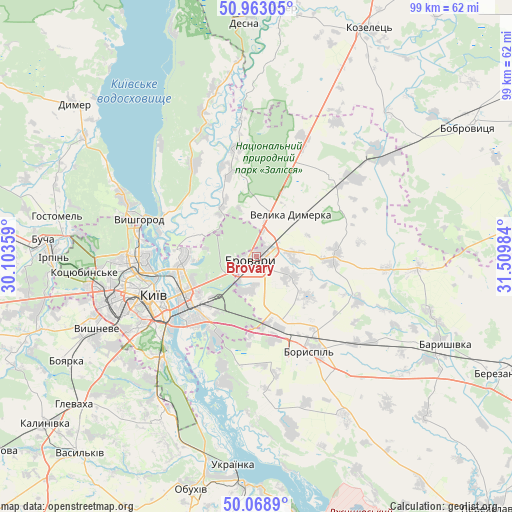
Brovary GPS coordinates[2]
50° 31' 5.124" North, 30° 48' 24.156" East
| Map corner | latitude | longitude |
|---|---|---|
| Upper-left | 50.96305°, | 30.10359° |
| Center: | 50.51809°, | 30.80671° |
| Lower-right: | 50.0689°, | 31.50984° |
| Map W x H: | 99.4×99.4 km | = 61.8×61.8mi |
| max Lat: | 52.18903° ⇑8.9% North |
| Brovary: | 50.51809° |
| min Lat: | ⇓91.1% South 44.39214° |
| min Long | Brovary | max Long |
| 22.20555° | 30.80671° | 40.13222° |
| W 37.4%⇐ | ⇒62.6% E |
Elevation
Elevation of Brovary is 130 m = 427 ft, and this is 25.8 m = 85 ft below average elevation for this country.
| Max E: |
886 m = 2907 ft | 51.1% |
| Avg. | 155.8 m = 511 ft | |
| Brovary | 130 m = 427 ft | |
Min E: |
-3 m = -10 ft | 48.9% |
See also: Brovary elevation on elevation.city.
Geographical zone
Brovary is located in North temperate zone (between Tropic of Cancer and the Arctic Circle). Distance of this North polar circle is 1784.1 km =1108.6 mi to North.| Distance of | km | miles | from Brovary |
|---|---|---|---|
| North Pole | 4390 | 2727.8 | to North |
| Arctic Circle | 1784.1 | 1108.6 | to North |
| Tropic Cancer | 3011.2 | 1871.1 | to South |
| Equator | 5617.1 | 3490.3 | to South |


Nearby cities:
15 places around Brovary: (largest is in red/bold)
• Boryspil’
21.2 km =13.2 mi,  150°
150°
• Hnidyn
22.1 km =13.7 mi,  197°
197°
• Khotiv
31.8 km =19.8 mi,  228°
228°
• Khotyanivka
18.8 km =11.7 mi,  297°
297°
• Kirove
27.7 km =17.2 mi,  126°
126°
• Knyazhichi
6.4 km =4 mi,  194°
194°
• Kyiv
21.2 km =13.2 mi,  250°
250°
• Novi Petrivtsi
28.4 km =17.6 mi, 295°
• Pohreby
12.2 km =7.6 mi,  289°
289°
• Prolisky
14.2 km =8.8 mi, 187°
• Pukhivka
12 km =7.5 mi,  328°
328°
• Semypolky
24.8 km =15.4 mi,  21°
21°
• Trebukhiv
7.8 km =4.8 mi,  118°
118°
• Velyka Dymerka
10.8 km =6.7 mi,  39°
39°
• Vyshhorod
23.6 km =14.7 mi, 288°
Sources, notices
• [Note1] Compared only with cities in Ukraine existing in our database
• [Src1] Map data: © OpenStreetMap contributors (CC-BY-SA)
• [Src2] Other city data from geonames.org with taken over terms of usage.
• [Src3] Geographical zone / Annual Mean Temperature by Robert A. Rohde @ Wikipedia
