Illintsi geodata
Illintsi (Vinnyts'ka) is a seat of a second-order administrative division; located in Ukraine in Europe/Kiev (GMT+3) time zone. With population of 10,770 people, there are 335 cities with bigger population in this country. Compared to other cities in Ukraine, 68.5% of cities are located further ↓South; 71.7% of cities are located further →East and 72.2% of cities have lower elevation than Illintsi. Note1


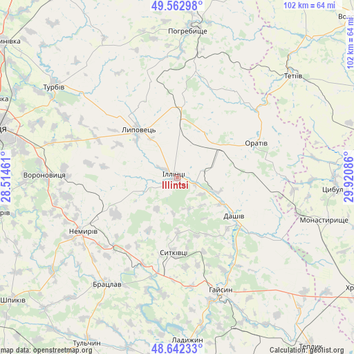
Illintsi GPS coordinates[2]
49° 6' 17.244" North, 29° 13' 3.828" East
| Map corner | latitude | longitude |
|---|---|---|
| Upper-left | 49.56298°, | 28.51461° |
| Center: | 49.10479°, | 29.21773° |
| Lower-right: | 48.64233°, | 29.92086° |
| Map W x H: | 102.4×102.4 km | = 63.6×63.6mi |
| max Lat: | 52.18903° ⇑31.5% North |
| Illintsi: | 49.10479° |
| min Lat: | ⇓68.5% South 44.39214° |
| min Long | Illintsi | max Long |
| 22.20555° | 29.21773° | 40.13222° |
| W 28.3%⇐ | ⇒71.7% E |
Elevation
Elevation of Illintsi is 214 m = 702 ft, and this is 58.2 m = 191 ft above average elevation for this country.
| Max E: |
886 m = 2907 ft | 27.8% |
| Illintsi | 214 m 702 ft | |
| Avg. | 155.8 m = 511 ft | |
Min E: |
-3 m = -10 ft | 72.2% |
See also: Ukraine elevation on elevation.city.
Geographical zone
Illintsi is located in North temperate zone (between Tropic of Cancer and the Arctic Circle). Distance of this North polar circle is 1941.2 km =1206.2 mi to North.| Distance of | km | miles | from Illintsi |
|---|---|---|---|
| North Pole | 4547.1 | 2825.4 | to North |
| Arctic Circle | 1941.2 | 1206.2 | to North |
| Tropic Cancer | 2854 | 1773.4 | to South |
| Equator | 5459.9 | 3392.6 | to South |


Nearby cities:
15 places around Illintsi: (largest is in red/bold)
• Bratslav
37.3 km =23.2 mi,  212°
212°
• Dashiv
18.8 km =11.7 mi,  126°
126°
• Haisyn
35 km =21.7 mi,  158°
158°
• Ladyzhyn
46.7 km =29 mi,  178°
178°
• Lypovets
18.2 km =11.3 mi,  319°
319°
• Monastyryshche
44.6 km =27.7 mi,  106°
106°
• Nemyriv
31.4 km =19.5 mi,  241°
241°
• Nova Pryluka
48.1 km =29.9 mi,  308°
308°
• Nove-Misto
46.6 km =29 mi, 107°
• Orativ
24.4 km =15.2 mi,  67°
67°
• Pohrebyshche
42.6 km =26.5 mi,  4°
4°
• Tetiiv
44.4 km =27.6 mi,  47°
47°
• Tsibulev
45.9 km =28.5 mi,  93°
93°
• Turbiv
45.1 km =28 mi, 306°
• Voronovytsya
39.1 km =24.3 mi,  270°
270°
Sources, notices
• [Note1] Compared only with cities in Ukraine existing in our database
• [Src1] Map data: © OpenStreetMap contributors (CC-BY-SA)
• [Src2] Other city data from geonames.org with taken over terms of usage.
• [Src3] Geographical zone / Annual Mean Temperature by Robert A. Rohde @ Wikipedia
