Bratslav geodata
Bratslav (Vinnyts'ka) is a populated place; located in Ukraine in Europe/Kiev (GMT+2) time zone. With population of 5,819 people, there are 576 cities with bigger population in this country. Compared to other cities in Ukraine, 62.6% of cities are located further ↓South; 72.7% of cities are located further →East and 72.6% of cities have lower elevation than Bratslav. Note1


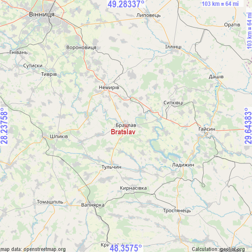
Bratslav GPS coordinates[2]
48° 49' 21.252" North, 28° 56' 26.52" East
| Map corner | latitude | longitude |
|---|---|---|
| Upper-left | 49.28337°, | 28.23758° |
| Center: | 48.82257°, | 28.9407° |
| Lower-right: | 48.3575°, | 29.64383° |
| Map W x H: | 102.9×102.9 km | = 63.9×63.9mi |
| max Lat: | 52.18903° ⇑37.4% North |
| Bratslav: | 48.82257° |
| min Lat: | ⇓62.6% South 44.39214° |
| min Long | Bratslav | max Long |
| 22.20555° | 28.9407° | 40.13222° |
| W 27.3%⇐ | ⇒72.7% E |
Elevation
Elevation of Bratslav is 215 m = 705 ft, and this is 59.2 m = 194 ft above average elevation for this country.
| Max E: |
886 m = 2907 ft | 27.4% |
| Bratslav | 215 m 705 ft | |
| Avg. | 155.8 m = 511 ft | |
Min E: |
-3 m = -10 ft | 72.6% |
See also: Ukraine elevation on elevation.city.
Geographical zone
Bratslav is located in North temperate zone (between Tropic of Cancer and the Arctic Circle). Distance of this North polar circle is 1972.6 km =1225.7 mi to North.| Distance of | km | miles | from Bratslav |
|---|---|---|---|
| North Pole | 4578.5 | 2844.9 | to North |
| Arctic Circle | 1972.6 | 1225.7 | to North |
| Tropic Cancer | 2822.6 | 1753.9 | to South |
| Equator | 5428.6 | 3373.2 | to South |


Nearby cities:
15 places around Bratslav: (largest is in red/bold)
• Dashiv
40.8 km =25.4 mi,  60°
60°
• Haisyn
32.9 km =20.4 mi,  92°
92°
• Illintsi
37.3 km =23.2 mi,  32°
32°
• Kryzhopil’
49.2 km =30.6 mi,  186°
186°
• Ladyzhyn
26.6 km =16.5 mi,  125°
125°
• Lypovets
46 km =28.6 mi,  10°
10°
• Nemyriv
18.1 km =11.2 mi,  335°
335°
• Sutysky
45.4 km =28.2 mi,  302°
302°
• Tomashpil’
44 km =27.3 mi,  224°
224°
• Trostyanets’
41 km =25.5 mi,  148°
148°
• Tsybulevka
49.9 km =31 mi,  166°
166°
• Tulchyn
17.9 km =11.1 mi,  202°
202°
• Tyvriv
38.1 km =23.7 mi, 303°
• Vapnyarka
35.1 km =21.8 mi, 204°
• Voronovytsya
37.1 km =23.1 mi,  329°
329°
Sources, notices
• [Note1] Compared only with cities in Ukraine existing in our database
• [Src1] Map data: © OpenStreetMap contributors (CC-BY-SA)
• [Src2] Other city data from geonames.org with taken over terms of usage.
• [Src3] Geographical zone / Annual Mean Temperature by Robert A. Rohde @ Wikipedia
