Monastyryshche geodata
Monastyryshche (Cherkasy) is a seat of a second-order administrative division; located in Ukraine in Europe/Kiev (GMT+3) time zone. With population of 9,111 people, there are 395 cities with bigger population in this country. Compared to other cities in Ukraine, 66.1% of cities are located further ↓South; 68.8% of cities are located further →East and 79.9% of cities have lower elevation than Monastyryshche. Note1


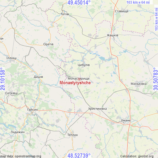
Monastyryshche GPS coordinates[2]
48° 59' 27.24" North, 29° 48' 16.92" East
| Map corner | latitude | longitude |
|---|---|---|
| Upper-left | 49.45014°, | 29.10158° |
| Center: | 48.9909°, | 29.8047° |
| Lower-right: | 48.52739°, | 30.50783° |
| Map W x H: | 102.6×102.6 km | = 63.8×63.8mi |
| max Lat: | 52.18903° ⇑33.9% North |
| Monastyryshche: | 48.9909° |
| min Lat: | ⇓66.1% South 44.39214° |
| min Long | Monastyryshche | max Long |
| 22.20555° | 29.8047° | 40.13222° |
| W 31.2%⇐ | ⇒68.8% E |
Elevation
Elevation of Monastyryshche is 246 m = 807 ft, and this is 90.2 m = 296 ft above average elevation for this country.
| Max E: |
886 m = 2907 ft | 20.1% |
| Monastyryshche | 246 m 807 ft | |
| Avg. | 155.8 m = 511 ft | |
Min E: |
-3 m = -10 ft | 79.9% |
See also: Ukraine elevation on elevation.city.
Geographical zone
Monastyryshche is located in North temperate zone (between Tropic of Cancer and the Arctic Circle). Distance of this North polar circle is 1953.9 km =1214.1 mi to North.| Distance of | km | miles | from Monastyryshche |
|---|---|---|---|
| North Pole | 4559.8 | 2833.3 | to North |
| Arctic Circle | 1953.9 | 1214.1 | to North |
| Tropic Cancer | 2841.4 | 1765.6 | to South |
| Equator | 5447.3 | 3384.8 | to South |


Nearby cities:
15 places around Monastyryshche: (largest is in red/bold)
• Buky
45.1 km =28 mi,  75°
75°
• Dashiv
27.7 km =17.2 mi,  273°
273°
• Haisyn
36.3 km =22.6 mi,  236°
236°
• Illintsi
44.6 km =27.7 mi,  286°
286°
• Khrystynivka
23.2 km =14.4 mi,  147°
147°
• Mankivka
38.7 km =24 mi,  94°
94°
• Nove-Misto
2 km =1.2 mi,  122°
122°
• Orativ
29.9 km =18.6 mi,  317°
317°
• Tanske
48.2 km =30 mi, 117°
• Teplyk
36.4 km =22.6 mi,  186°
186°
• Tetiiv
44.1 km =27.4 mi,  346°
346°
• Tsibulev
10.3 km =6.4 mi,  17°
17°
• Uman
40.7 km =25.3 mi,  131°
131°
• Verkhniachka
24.9 km =15.5 mi,  136°
136°
• Zhashkiv
36 km =22.4 mi,  38°
38°
Sources, notices
• [Note1] Compared only with cities in Ukraine existing in our database
• [Src1] Map data: © OpenStreetMap contributors (CC-BY-SA)
• [Src2] Other city data from geonames.org with taken over terms of usage.
• [Src3] Geographical zone / Annual Mean Temperature by Robert A. Rohde @ Wikipedia
