Orativ geodata
Orativ (Vinnyts'ka) is a seat of a second-order administrative division; located in Ukraine in Europe/Kiev (GMT+3) time zone. With population of 3,170 people, there are 894 cities with bigger population in this country. Compared to other cities in Ukraine, 69.6% of cities are located further ↓South; 70.3% of cities are located further →East and 76.6% of cities have lower elevation than Orativ. Note1


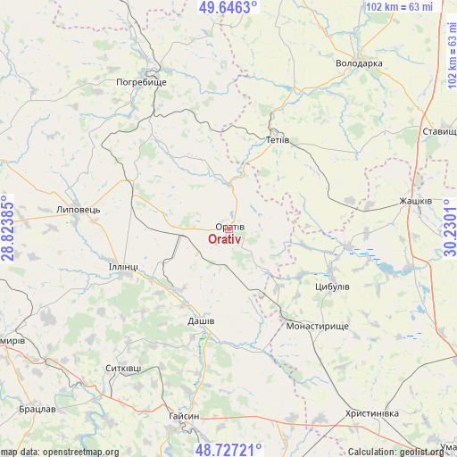
Orativ GPS coordinates[2]
49° 11' 20.004" North, 29° 31' 37.092" East
| Map corner | latitude | longitude |
|---|---|---|
| Upper-left | 49.6463°, | 28.82385° |
| Center: | 49.18889°, | 29.52697° |
| Lower-right: | 48.72721°, | 30.2301° |
| Map W x H: | 102.2×102.2 km | = 63.5×63.5mi |
| max Lat: | 52.18903° ⇑30.4% North |
| Orativ: | 49.18889° |
| min Lat: | ⇓69.6% South 44.39214° |
| min Long | Orativ | max Long |
| 22.20555° | 29.52697° | 40.13222° |
| W 29.7%⇐ | ⇒70.3% E |
Elevation
Elevation of Orativ is 232 m = 761 ft, and this is 76.2 m = 250 ft above average elevation for this country.
| Max E: |
886 m = 2907 ft | 23.4% |
| Orativ | 232 m 761 ft | |
| Avg. | 155.8 m = 511 ft | |
Min E: |
-3 m = -10 ft | 76.6% |
See also: Ukraine elevation on elevation.city.
Geographical zone
Orativ is located in North temperate zone (between Tropic of Cancer and the Arctic Circle). Distance of this North polar circle is 1931.9 km =1200.4 mi to North.| Distance of | km | miles | from Orativ |
|---|---|---|---|
| North Pole | 4537.8 | 2819.7 | to North |
| Arctic Circle | 1931.9 | 1200.4 | to North |
| Tropic Cancer | 2863.4 | 1779.2 | to South |
| Equator | 5469.3 | 3398.5 | to South |


Nearby cities:
15 places around Orativ: (largest is in red/bold)
• Dashiv
21.8 km =13.5 mi,  199°
199°
• Haisyn
43.1 km =26.8 mi,  193°
193°
• Illintsi
24.4 km =15.2 mi,  247°
247°
• Khrystynivka
52.9 km =32.9 mi,  141°
141°
• Lobachiv
37.7 km =23.4 mi,  44°
44°
• Lypovets
34.5 km =21.4 mi,  277°
277°
• Monastyryshche
29.9 km =18.6 mi, 137°
• Nove-Misto
31.9 km =19.8 mi, 136°
• Pohrebyshche
38.2 km =23.7 mi,  330°
330°
• Roskoshnyy
51.8 km =32.2 mi,  67°
67°
• Stavyshche
53.1 km =33 mi,  64°
64°
• Tetiiv
23.2 km =14.4 mi,  25°
25°
• Tsibulev
26.3 km =16.3 mi,  117°
117°
• Volodarka
46.6 km =29 mi, 36°
• Zhashkiv
42.8 km =26.6 mi,  81°
81°
Sources, notices
• [Note1] Compared only with cities in Ukraine existing in our database
• [Src1] Map data: © OpenStreetMap contributors (CC-BY-SA)
• [Src2] Other city data from geonames.org with taken over terms of usage.
• [Src3] Geographical zone / Annual Mean Temperature by Robert A. Rohde @ Wikipedia
