Tetiiv geodata
Tetiiv (Kyiv) is a seat of a second-order administrative division; located in Ukraine in Europe/Kiev (GMT+3) time zone. With population of 14,388 people, there are 263 cities with bigger population in this country. Compared to other cities in Ukraine, 72.1% of cities are located further ↓South; 69.5% of cities are located further →East and 67.3% of cities have lower elevation than Tetiiv. Note1


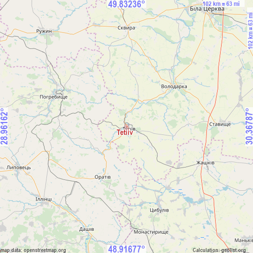
Tetiiv GPS coordinates[2]
49° 22' 36.12" North, 29° 39' 53.064" East
| Map corner | latitude | longitude |
|---|---|---|
| Upper-left | 49.83236°, | 28.96162° |
| Center: | 49.3767°, | 29.66474° |
| Lower-right: | 48.91677°, | 30.36787° |
| Map W x H: | 101.8×101.8 km | = 63.3×63.3mi |
| max Lat: | 52.18903° ⇑27.9% North |
| Tetiiv: | 49.3767° |
| min Lat: | ⇓72.1% South 44.39214° |
| min Long | Tetiiv | max Long |
| 22.20555° | 29.66474° | 40.13222° |
| W 30.5%⇐ | ⇒69.5% E |
Elevation
Elevation of Tetiiv is 195 m = 640 ft, and this is 39.2 m = 129 ft above average elevation for this country.
| Max E: |
886 m = 2907 ft | 32.7% |
| Tetiiv | 195 m 640 ft | |
| Avg. | 155.8 m = 511 ft | |
Min E: |
-3 m = -10 ft | 67.3% |
See also: Ukraine elevation on elevation.city.
Geographical zone
Tetiiv is located in North temperate zone (between Tropic of Cancer and the Arctic Circle). Distance of this North polar circle is 1911 km =1187.4 mi to North.| Distance of | km | miles | from Tetiiv |
|---|---|---|---|
| North Pole | 4516.9 | 2806.7 | to North |
| Arctic Circle | 1911 | 1187.4 | to North |
| Tropic Cancer | 2884.3 | 1792.2 | to South |
| Equator | 5490.2 | 3411.5 | to South |


Nearby cities:
15 places around Tetiiv: (largest is in red/bold)
• Dashiv
44.9 km =27.9 mi,  202°
202°
• Illintsi
44.4 km =27.6 mi,  227°
227°
• Lobachiv
17.5 km =10.9 mi,  70°
70°
• Monastyryshche
44.1 km =27.4 mi,  166°
166°
• Nove-Misto
45.6 km =28.3 mi,  164°
164°
• Orativ
23.2 km =14.4 mi,  205°
205°
• Pohrebyshche
31.5 km =19.6 mi,  292°
292°
• Roskoshnyy
37.7 km =23.4 mi,  90°
90°
• Skvyra
39.5 km =24.5 mi,  0°
0°
• Stavyshche
38.1 km =23.7 mi, 87°
• Topory
39.6 km =24.6 mi,  320°
320°
• Tsibulev
35.6 km =22.1 mi, 158°
• Volodarka
24.3 km =15.1 mi,  47°
47°
• Zarudyntsi
45.9 km =28.5 mi,  311°
311°
• Zhashkiv
35.4 km =22 mi,  114°
114°
Sources, notices
• [Note1] Compared only with cities in Ukraine existing in our database
• [Src1] Map data: © OpenStreetMap contributors (CC-BY-SA)
• [Src2] Other city data from geonames.org with taken over terms of usage.
• [Src3] Geographical zone / Annual Mean Temperature by Robert A. Rohde @ Wikipedia
