Abrikosovo geodata
Abrikosovo (Republic of Crimea) is a seat of a third-order administrative division; located in Ukraine in Europe/Simferopol (GMT+3) time zone. With population of 778 people, there are 1501 cities with bigger population in this country. Compared to other cities in Ukraine, 73.7% of cities are located further ↑North; 65.4% of cities are located further ←West and 86.4% of cities have higher elevation than Abrikosovo. Note1
Administrative division(s):
- Level 1: Republic of Crimea
- Level 2: Pervomayskiy rayon
- Level 3: Abrikosovskoye sel'skoye poselenye


Abrikosovo GPS coordinates[2]
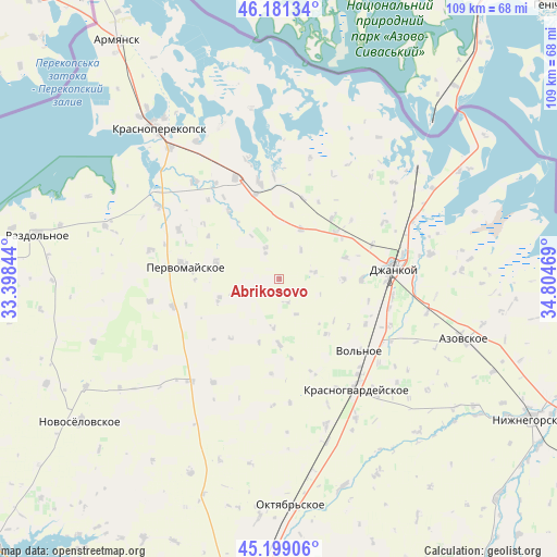
45° 41' 32.496" North, 34° 6' 5.616" East
| Map corner | latitude | longitude |
|---|---|---|
| Upper-left | 46.18134°, | 33.39844° |
| Center: | 45.69236°, | 34.10156° |
| Lower-right: | 45.19906°, | 34.80469° |
| Map W x H: | 109.2×109.2 km | = 67.9×67.9mi |
| max Lat: | 52.18903° ⇑73.7% North |
| Abrikosovo: | 45.69236° |
| min Lat: | ⇓26.3% South 44.39214° |
| min Long | Abrikosovo | max Long |
| 22.20555° | 34.10156° | 40.13222° |
| W 65.4%⇐ | ⇒34.6% E |
Elevation
Elevation of Abrikosovo is 26 m = 85 ft, and this is 129.8 m = 426 ft below average elevation for this country.
| Max E: |
886 m = 2907 ft | 86.4% |
| Avg. | 155.8 m = 511 ft | |
| Abrikosovo | 26 m = 85 ft | |
Min E: |
-3 m = -10 ft | 13.6% |
See also: Ukraine elevation on elevation.city.
Geographical zone
Abrikosovo is located in North temperate zone (between Tropic of Cancer and the Arctic Circle). Distance of this North polar circle is 2320.7 km =1442 mi to North.| Distance of | km | miles | from Abrikosovo |
|---|---|---|---|
| North Pole | 4926.5 | 3061.2 | to North |
| Arctic Circle | 2320.7 | 1442 | to North |
| Tropic Cancer | 2474.6 | 1537.6 | to South |
| Equator | 5080.5 | 3156.9 | to South |


Nearby cities:
15 places around Abrikosovo: (largest is in red/bold)
• Aleksandrovka
12.9 km =8 mi,  180°
180°
• Hvardiiske
15.2 km =9.4 mi,  219°
219°
• Kalinino
14.2 km =8.8 mi,  139°
139°
• Krest’yanovka
13 km =8.1 mi,  284°
284°
• Krymka
6.8 km =4.2 mi,  78°
78°
• Lobanovo
14.3 km =8.9 mi,  49°
49°
• Luganskoye
16.1 km =10 mi,  40°
40°
• Mar’ino
13.6 km =8.5 mi,  72°
72°
• Mirnovka
16.2 km =10.1 mi,  90°
90°
• Novokrymskoye
10.6 km =6.6 mi,  23°
23°
• Oktyabr’skoye
12.5 km =7.8 mi,  250°
250°
• Ostrovskoye
6.2 km =3.9 mi,  333°
333°
• Roskoshnoye
4.6 km =2.9 mi,  166°
166°
• Yarkoye
12.6 km =7.8 mi, 90°
• Zernovoye
7.7 km =4.8 mi,  154°
154°
Sources, notices
• [Note1] Compared only with cities in Ukraine existing in our database
• [Src1] Map data: © OpenStreetMap contributors (CC-BY-SA)
• [Src2] Other city data from geonames.org with taken over terms of usage.
• [Src3] Geographical zone / Annual Mean Temperature by Robert A. Rohde @ Wikipedia
