Fastiv geodata
Fastiv (Kyiv) is a seat of a second-order administrative division; located in Ukraine in Europe/Kiev (GMT+3) time zone. With population of 51,143 people, there are 93 cities with bigger population in this country. Compared to other cities in Ukraine, 84.9% of cities are located further ↓South; 68.2% of cities are located further →East and 70.6% of cities have lower elevation than Fastiv. Note1


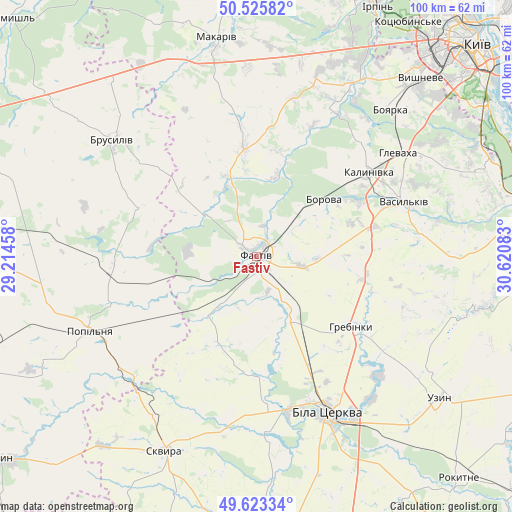
Fastiv GPS coordinates[2]
50° 4' 36.12" North, 29° 55' 3.72" East
| Map corner | latitude | longitude |
|---|---|---|
| Upper-left | 50.52582°, | 29.21458° |
| Center: | 50.0767°, | 29.9177° |
| Lower-right: | 49.62334°, | 30.62083° |
| Map W x H: | 100.3×100.3 km | = 62.3×62.3mi |
| max Lat: | 52.18903° ⇑15.1% North |
| Fastiv: | 50.0767° |
| min Lat: | ⇓84.9% South 44.39214° |
| min Long | Fastiv | max Long |
| 22.20555° | 29.9177° | 40.13222° |
| W 31.8%⇐ | ⇒68.2% E |
Elevation
Elevation of Fastiv is 208 m = 682 ft, and this is 52.2 m = 171 ft above average elevation for this country.
| Max E: |
886 m = 2907 ft | 29.4% |
| Fastiv | 208 m 682 ft | |
| Avg. | 155.8 m = 511 ft | |
Min E: |
-3 m = -10 ft | 70.6% |
See also: Fastiv elevation on elevation.city.
Geographical zone
Fastiv is located in North temperate zone (between Tropic of Cancer and the Arctic Circle). Distance of this North polar circle is 1833.2 km =1139.1 mi to North.| Distance of | km | miles | from Fastiv |
|---|---|---|---|
| North Pole | 4439.1 | 2758.3 | to North |
| Arctic Circle | 1833.2 | 1139.1 | to North |
| Tropic Cancer | 2962.1 | 1840.6 | to South |
| Equator | 5568 | 3459.8 | to South |


Nearby cities:
15 places around Fastiv: (largest is in red/bold)
• Bila Tserkva
32.8 km =20.4 mi,  154°
154°
• Bobrytsya
36 km =22.4 mi,  32°
32°
• Borova
17.3 km =10.7 mi,  50°
50°
• Boyarka
38.2 km =23.7 mi, 45°
• Brusyliv
36.2 km =22.5 mi,  309°
309°
• Buky
32.7 km =20.3 mi,  216°
216°
• Hlevakha
36.5 km =22.7 mi, 53°
• Kornyn
27.3 km =17 mi,  274°
274°
• Kozhanka
16 km =9.9 mi, 223°
• Kvitneve
29.3 km =18.2 mi,  250°
250°
• Motovylivka
14.4 km =8.9 mi, 50°
• Popilnia
36 km =22.4 mi, 247°
• Skvyra
42.4 km =26.3 mi,  205°
205°
• Vasylkiv
30.8 km =19.1 mi,  66°
66°
• Yasnohorodka
31.9 km =19.8 mi,  13°
13°
Sources, notices
• [Note1] Compared only with cities in Ukraine existing in our database
• [Src1] Map data: © OpenStreetMap contributors (CC-BY-SA)
• [Src2] Other city data from geonames.org with taken over terms of usage.
• [Src3] Geographical zone / Annual Mean Temperature by Robert A. Rohde @ Wikipedia
