Bila Tserkva geodata
Bila Tserkva (Kyiv) is a seat of a second-order administrative division; located in Ukraine in Europe/Kiev (GMT+3) time zone. With population of 199,163 people, there are 31 cities with bigger population in this country. Compared to other cities in Ukraine, 79.7% of cities are located further ↓South; 67.1% of cities are located further →East and 62.7% of cities have lower elevation than Bila Tserkva. Note1


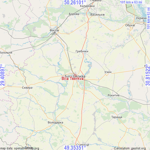
Bila Tserkva GPS coordinates[2]
49° 48' 33.804" North, 30° 6' 43.524" East
| Map corner | latitude | longitude |
|---|---|---|
| Upper-left | 50.26101°, | 29.40897° |
| Center: | 49.80939°, | 30.11209° |
| Lower-right: | 49.35351°, | 30.81522° |
| Map W x H: | 100.9×100.9 km | = 62.7×62.7mi |
| max Lat: | 52.18903° ⇑20.3% North |
| Bila Tserkva: | 49.80939° |
| min Lat: | ⇓79.7% South 44.39214° |
| min Long | Bila Tserkva | max Long |
| 22.20555° | 30.11209° | 40.13222° |
| W 32.9%⇐ | ⇒67.1% E |
Elevation
Elevation of Bila Tserkva is 178 m = 584 ft, and this is 22.2 m = 73 ft above average elevation for this country.
| Max E: |
886 m = 2907 ft | 37.3% |
| Bila Tserkva | 178 m 584 ft | |
| Avg. | 155.8 m = 511 ft | |
Min E: |
-3 m = -10 ft | 62.7% |
See also: Bila Tserkva elevation on elevation.city.
Geographical zone
Bila Tserkva is located in North temperate zone (between Tropic of Cancer and the Arctic Circle). Distance of this North polar circle is 1862.9 km =1157.6 mi to North.| Distance of | km | miles | from Bila Tserkva |
|---|---|---|---|
| North Pole | 4468.8 | 2776.8 | to North |
| Arctic Circle | 1862.9 | 1157.6 | to North |
| Tropic Cancer | 2932.4 | 1822.1 | to South |
| Equator | 5538.3 | 3441.3 | to South |


Nearby cities:
15 places around Bila Tserkva: (largest is in red/bold)
• Borova
40.8 km =25.4 mi,  359°
359°
• Buky
33.7 km =20.9 mi,  275°
275°
• Fastiv
32.8 km =20.4 mi,  334°
334°
• Kozhanka
30.8 km =19.1 mi,  306°
306°
• Kvitneve
46.1 km =28.6 mi,  295°
295°
• Lobachiv
45 km =28 mi,  200°
200°
• Mirovka
39 km =24.2 mi,  69°
69°
• Motovylivka
38.9 km =24.2 mi, 356°
• Rokytne
29.4 km =18.3 mi,  117°
117°
• Skvyra
33.2 km =20.6 mi,  254°
254°
• Stavyshche
46.8 km =29.1 mi,  173°
173°
• Tarashcha
39.1 km =24.3 mi,  135°
135°
• Uzyn
21.8 km =13.5 mi,  85°
85°
• Vasylkiv
44.4 km =27.6 mi,  18°
18°
• Volodarka
34.8 km =21.6 mi, 204°
In other languages:
- In German: Bila Zerkwa
- In Italian: Bila Cerkva
- In Russian: Белая Церковь, Belaya Tserkov’
- In Chinese: 白采尔科维
Sources, notices
• [Note1] Compared only with cities in Ukraine existing in our database
• [Src1] Map data: © OpenStreetMap contributors (CC-BY-SA)
• [Src2] Other city data from geonames.org with taken over terms of usage.
• [Src3] Geographical zone / Annual Mean Temperature by Robert A. Rohde @ Wikipedia
