Popilnia geodata
Popilnia (Zhytomyr) is a populated place; located in Ukraine in Europe/Kiev (GMT+3) time zone. With population of 6,109 people, there are 563 cities with bigger population in this country. Compared to other cities in Ukraine, 82.7% of cities are located further ↓South; 70.6% of cities are located further →East and 70% of cities have lower elevation than Popilnia. Note1


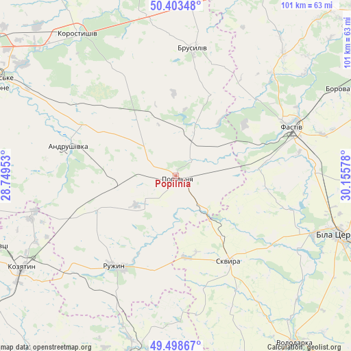
Popilnia GPS coordinates[2]
49° 57' 11.52" North, 29° 27' 9.54" East
| Map corner | latitude | longitude |
|---|---|---|
| Upper-left | 50.40348°, | 28.74953° |
| Center: | 49.9532°, | 29.45265° |
| Lower-right: | 49.49867°, | 30.15578° |
| Map W x H: | 100.6×100.6 km | = 62.5×62.5mi |
| max Lat: | 52.18903° ⇑17.3% North |
| Popilnia: | 49.9532° |
| min Lat: | ⇓82.7% South 44.39214° |
| min Long | Popilnia | max Long |
| 22.20555° | 29.45265° | 40.13222° |
| W 29.4%⇐ | ⇒70.6% E |
Elevation
Elevation of Popilnia is 206 m = 676 ft, and this is 50.2 m = 165 ft above average elevation for this country.
| Max E: |
886 m = 2907 ft | 30% |
| Popilnia | 206 m 676 ft | |
| Avg. | 155.8 m = 511 ft | |
Min E: |
-3 m = -10 ft | 70% |
See also: Ukraine elevation on elevation.city.
Geographical zone
Popilnia is located in North temperate zone (between Tropic of Cancer and the Arctic Circle). Distance of this North polar circle is 1846.9 km =1147.6 mi to North.| Distance of | km | miles | from Popilnia |
|---|---|---|---|
| North Pole | 4452.8 | 2766.8 | to North |
| Arctic Circle | 1846.9 | 1147.6 | to North |
| Tropic Cancer | 2948.4 | 1832.1 | to South |
| Equator | 5554.3 | 3451.3 | to South |


Nearby cities:
15 places around Popilnia: (largest is in red/bold)
• Andrushivka
31.9 km =19.8 mi,  284°
284°
• Andrushky
11.1 km =6.9 mi,  224°
224°
• Brovky Pershi
18.4 km =11.4 mi,  262°
262°
• Brusyliv
37.2 km =23.1 mi,  8°
8°
• Buky
18.6 km =11.6 mi,  132°
132°
• Bystriivka
18.3 km =11.4 mi,  226°
226°
• Chornorudka
30.5 km =19 mi,  247°
247°
• Fastiv
36 km =22.4 mi,  67°
67°
• Golubivka
36.8 km =22.9 mi,  214°
214°
• Kornyn
16.9 km =10.5 mi,  20°
20°
• Kozhanka
22.4 km =13.9 mi,  84°
84°
• Kvitneve
6.8 km =4.2 mi,  55°
55°
• Ruzhyn
31.2 km =19.4 mi, 214°
• Skvyra
29 km =18 mi,  148°
148°
• Topory
34.9 km =21.7 mi,  196°
196°
Sources, notices
• [Note1] Compared only with cities in Ukraine existing in our database
• [Src1] Map data: © OpenStreetMap contributors (CC-BY-SA)
• [Src2] Other city data from geonames.org with taken over terms of usage.
• [Src3] Geographical zone / Annual Mean Temperature by Robert A. Rohde @ Wikipedia
