Brusyliv geodata
Brusyliv (Zhytomyr) is a seat of a second-order administrative division; located in Ukraine in Europe/Kiev (GMT+3) time zone. With population of 5,242 people, there are 625 cities with bigger population in this country. Compared to other cities in Ukraine, 87.8% of cities are located further ↓South; 70.3% of cities are located further →East and 59.2% of cities have lower elevation than Brusyliv. Note1


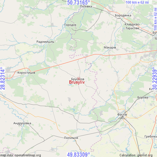
Brusyliv GPS coordinates[2]
50° 17' 4.164" North, 29° 31' 34.536" East
| Map corner | latitude | longitude |
|---|---|---|
| Upper-left | 50.73165°, | 28.82314° |
| Center: | 50.28449°, | 29.52626° |
| Lower-right: | 49.83309°, | 30.22939° |
| Map W x H: | 99.9×99.9 km | = 62.1×62.1mi |
| max Lat: | 52.18903° ⇑12.2% North |
| Brusyliv: | 50.28449° |
| min Lat: | ⇓87.8% South 44.39214° |
| min Long | Brusyliv | max Long |
| 22.20555° | 29.52626° | 40.13222° |
| W 29.7%⇐ | ⇒70.3% E |
Elevation
Elevation of Brusyliv is 166 m = 545 ft, and this is 10.2 m = 33 ft above average elevation for this country.
| Max E: |
886 m = 2907 ft | 40.8% |
| Brusyliv | 166 m 545 ft | |
| Avg. | 155.8 m = 511 ft | |
Min E: |
-3 m = -10 ft | 59.2% |
See also: Ukraine elevation on elevation.city.
Geographical zone
Brusyliv is located in North temperate zone (between Tropic of Cancer and the Arctic Circle). Distance of this North polar circle is 1810.1 km =1124.7 mi to North.| Distance of | km | miles | from Brusyliv |
|---|---|---|---|
| North Pole | 4416 | 2744 | to North |
| Arctic Circle | 1810.1 | 1124.7 | to North |
| Tropic Cancer | 2985.2 | 1854.9 | to South |
| Equator | 5591.1 | 3474.1 | to South |


Nearby cities:
15 places around Brusyliv: (largest is in red/bold)
• Bila Krynytsya
39.7 km =24.7 mi,  354°
354°
• Borova
42.8 km =26.6 mi,  106°
106°
• Fastiv
36.2 km =22.5 mi,  129°
129°
• Horodok
34.8 km =21.6 mi, 352°
• Kodra
34.6 km =21.5 mi,  3°
3°
• Kornyn
21 km =13 mi,  178°
178°
• Korostyshiv
33.6 km =20.9 mi,  276°
276°
• Kozhanka
38.6 km =24 mi,  153°
153°
• Kvitneve
33 km =20.5 mi, 179°
• Makariv
28.4 km =17.6 mi,  45°
45°
• Motovylivka
41.4 km =25.7 mi, 109°
• Popilnia
37.2 km =23.1 mi,  188°
188°
• Radomyshl
31.6 km =19.6 mi,  318°
318°
• Stavyshche
12.9 km =8 mi, 0°
• Yasnohorodka
36.1 km =22.4 mi,  77°
77°
Sources, notices
• [Note1] Compared only with cities in Ukraine existing in our database
• [Src1] Map data: © OpenStreetMap contributors (CC-BY-SA)
• [Src2] Other city data from geonames.org with taken over terms of usage.
• [Src3] Geographical zone / Annual Mean Temperature by Robert A. Rohde @ Wikipedia
