Skvyra geodata
Skvyra (Kyiv) is a seat of a second-order administrative division; located in Ukraine in Europe/Kiev (GMT+3) time zone. With population of 17,452 people, there are 224 cities with bigger population in this country. Compared to other cities in Ukraine, 78.6% of cities are located further ↓South; 69.4% of cities are located further →East and 68.9% of cities have lower elevation than Skvyra. Note1


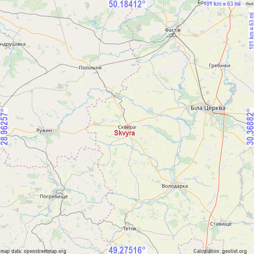
Skvyra GPS coordinates[2]
49° 43' 54.372" North, 29° 39' 56.484" East
| Map corner | latitude | longitude |
|---|---|---|
| Upper-left | 50.18412°, | 28.96257° |
| Center: | 49.73177°, | 29.66569° |
| Lower-right: | 49.27516°, | 30.36882° |
| Map W x H: | 101.1×101.1 km | = 62.8×62.8mi |
| max Lat: | 52.18903° ⇑21.4% North |
| Skvyra: | 49.73177° |
| min Lat: | ⇓78.6% South 44.39214° |
| min Long | Skvyra | max Long |
| 22.20555° | 29.66569° | 40.13222° |
| W 30.6%⇐ | ⇒69.4% E |
Elevation
Elevation of Skvyra is 201 m = 659 ft, and this is 45.2 m = 148 ft above average elevation for this country.
| Max E: |
886 m = 2907 ft | 31.1% |
| Skvyra | 201 m 659 ft | |
| Avg. | 155.8 m = 511 ft | |
Min E: |
-3 m = -10 ft | 68.9% |
See also: Ukraine elevation on elevation.city.
Geographical zone
Skvyra is located in North temperate zone (between Tropic of Cancer and the Arctic Circle). Distance of this North polar circle is 1871.5 km =1162.9 mi to North.| Distance of | km | miles | from Skvyra |
|---|---|---|---|
| North Pole | 4477.4 | 2782.1 | to North |
| Arctic Circle | 1871.5 | 1162.9 | to North |
| Tropic Cancer | 2923.7 | 1816.7 | to South |
| Equator | 5529.7 | 3436 | to South |


Nearby cities:
15 places around Skvyra: (largest is in red/bold)
• Andrushky
28.5 km =17.7 mi,  305°
305°
• Bila Tserkva
33.2 km =20.6 mi,  74°
74°
• Buky
12.2 km =7.6 mi,  353°
353°
• Bystriivka
31 km =19.3 mi,  292°
292°
• Golubivka
36.8 km =22.9 mi,  261°
261°
• Kozhanka
27.7 km =17.2 mi,  14°
14°
• Kvitneve
30.1 km =18.7 mi,  341°
341°
• Lobachiv
37.3 km =23.2 mi,  154°
154°
• Pohrebyshche
39.8 km =24.7 mi,  226°
226°
• Popilnia
29 km =18 mi,  328°
328°
• Ruzhyn
33.2 km =20.6 mi,  268°
268°
• Tetiiv
39.5 km =24.5 mi,  180°
180°
• Topory
26.6 km =16.5 mi,  250°
250°
• Volodarka
29.1 km =18.1 mi,  142°
142°
• Zarudyntsi
35.3 km =21.9 mi, 255°
Sources, notices
• [Note1] Compared only with cities in Ukraine existing in our database
• [Src1] Map data: © OpenStreetMap contributors (CC-BY-SA)
• [Src2] Other city data from geonames.org with taken over terms of usage.
• [Src3] Geographical zone / Annual Mean Temperature by Robert A. Rohde @ Wikipedia
