Vinkivtsi geodata
Vinkivtsi (Khmelnytskyi) is a seat of a second-order administrative division; located in Ukraine in Europe/Kiev (GMT+3) time zone. In our database, there are 1661 cities with bigger population. Compared to other cities in Ukraine, 67.2% of cities are located further ↓South; 77.6% of cities are located further →East and 91.1% of cities have lower elevation than Vinkivtsi. Note1


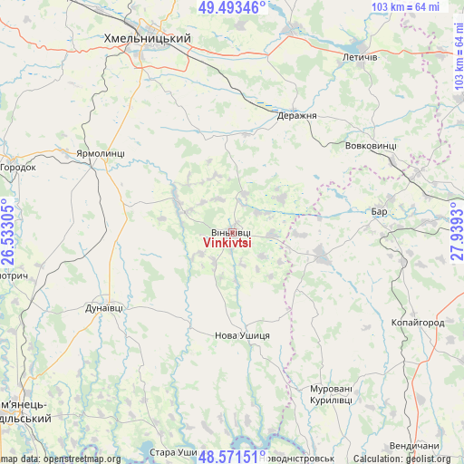
Vinkivtsi GPS coordinates[2]
49° 2' 4.632" North, 27° 14' 10.212" East
| Map corner | latitude | longitude |
|---|---|---|
| Upper-left | 49.49346°, | 26.53305° |
| Center: | 49.03462°, | 27.23617° |
| Lower-right: | 48.57151°, | 27.9393° |
| Map W x H: | 102.5×102.5 km | = 63.7×63.7mi |
| max Lat: | 52.18903° ⇑32.8% North |
| Vinkivtsi: | 49.03462° |
| min Lat: | ⇓67.2% South 44.39214° |
| min Long | Vinkivtsi | max Long |
| 22.20555° | 27.23617° | 40.13222° |
| W 22.4%⇐ | ⇒77.6% E |
Elevation
Elevation of Vinkivtsi is 314 m = 1030 ft, and this is 158.2 m = 519 ft above average elevation for this country.
| Max E: |
886 m = 2907 ft | 8.9% |
| Vinkivtsi | 314 m 1030 ft | |
| Avg. | 155.8 m = 511 ft | |
Min E: |
-3 m = -10 ft | 91.1% |
See also: Ukraine elevation on elevation.city.
Geographical zone
Vinkivtsi is located in North temperate zone (between Tropic of Cancer and the Arctic Circle). Distance of this North polar circle is 1949 km =1211.1 mi to North.| Distance of | km | miles | from Vinkivtsi |
|---|---|---|---|
| North Pole | 4554.9 | 2830.3 | to North |
| Arctic Circle | 1949 | 1211.1 | to North |
| Tropic Cancer | 2846.2 | 1768.5 | to South |
| Equator | 5452.1 | 3387.8 | to South |


Nearby cities:
15 places around Vinkivtsi: (largest is in red/bold)
• Bar
32.9 km =20.4 mi,  81°
81°
• Derazhnya
29.8 km =18.5 mi,  28°
28°
• Dunaivtsi
32.1 km =19.9 mi,  239°
239°
• Dunayivtsi
28.8 km =17.9 mi,  266°
266°
• Horodok
49.6 km =30.8 mi,  286°
286°
• Khmelnytskyi
46.4 km =28.8 mi,  337°
337°
• Kopayhorod
45.4 km =28.2 mi,  115°
115°
• Letychiv
48.1 km =29.9 mi,  36°
36°
• Makiv
47.9 km =29.8 mi, 236°
• Medzhybizh
46.4 km =28.8 mi,  15°
15°
• Murovani Kurylivtsi
40.3 km =25 mi,  149°
149°
• Nova Ushytsya
22.1 km =13.7 mi,  172°
172°
• Novodnistrovs’k
52.4 km =32.6 mi,  163°
163°
• Novoye Sëlo
35.4 km =22 mi,  296°
296°
• Yarmolyntsi
33.9 km =21.1 mi, 301°
Sources, notices
• [Note1] Compared only with cities in Ukraine existing in our database
• [Src1] Map data: © OpenStreetMap contributors (CC-BY-SA)
• [Src2] Other city data from geonames.org with taken over terms of usage.
• [Src3] Geographical zone / Annual Mean Temperature by Robert A. Rohde @ Wikipedia
