Makiv geodata
Makiv (Khmelnytskyi) is a populated place; located in Ukraine in Europe/Kiev (GMT+3) time zone. With population of 5,602 people, there are 599 cities with bigger population in this country. Compared to other cities in Ukraine, 61.9% of cities are located further ↓South; 78.7% of cities are located further →East and 83.7% of cities have lower elevation than Makiv. Note1


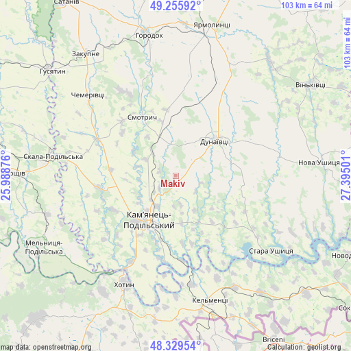
Makiv GPS coordinates[2]
48° 47' 41.532" North, 26° 41' 30.768" East
| Map corner | latitude | longitude |
|---|---|---|
| Upper-left | 49.25592°, | 25.98876° |
| Center: | 48.79487°, | 26.69188° |
| Lower-right: | 48.32954°, | 27.39501° |
| Map W x H: | 103×103 km | = 64×64mi |
| max Lat: | 52.18903° ⇑38.1% North |
| Makiv: | 48.79487° |
| min Lat: | ⇓61.9% South 44.39214° |
| min Long | Makiv | max Long |
| 22.20555° | 26.69188° | 40.13222° |
| W 21.3%⇐ | ⇒78.7% E |
Elevation
Elevation of Makiv is 266 m = 873 ft, and this is 110.2 m = 362 ft above average elevation for this country.
| Max E: |
886 m = 2907 ft | 16.3% |
| Makiv | 266 m 873 ft | |
| Avg. | 155.8 m = 511 ft | |
Min E: |
-3 m = -10 ft | 83.7% |
See also: Ukraine elevation on elevation.city.
Geographical zone
Makiv is located in North temperate zone (between Tropic of Cancer and the Arctic Circle). Distance of this North polar circle is 1975.7 km =1227.6 mi to North.| Distance of | km | miles | from Makiv |
|---|---|---|---|
| North Pole | 4581.6 | 2846.9 | to North |
| Arctic Circle | 1975.7 | 1227.6 | to North |
| Tropic Cancer | 2819.6 | 1752 | to South |
| Equator | 5425.5 | 3371.2 | to South |


Nearby cities:
15 places around Makiv: (largest is in red/bold)
• Chemerivtsi
35.2 km =21.9 mi,  313°
313°
• Dunaivtsi
16 km =9.9 mi,  48°
48°
• Dunayivtsi
27.4 km =17 mi,  23°
23°
• Horodok
41.8 km =26 mi,  349°
349°
• Husiatyn
45.9 km =28.5 mi, 311°
• Kamianets-Podilskyi
14.5 km =9 mi,  212°
212°
• Kel’mentsi
38.1 km =23.7 mi,  164°
164°
• Khotyn
35.2 km =21.9 mi,  204°
204°
• Nova Ushytsya
42.9 km =26.7 mi,  83°
83°
• Novoye Sëlo
42.9 km =26.7 mi,  10°
10°
• Skala-Podil’s’ka
36.6 km =22.7 mi,  279°
279°
• Smotrych
17.7 km =11 mi, 213°
• Yarmolyntsi
45.5 km =28.3 mi, 13°
• Zakupne
44.4 km =27.6 mi,  324°
324°
• Zhvanets
31.1 km =19.3 mi, 208°
Sources, notices
• [Note1] Compared only with cities in Ukraine existing in our database
• [Src1] Map data: © OpenStreetMap contributors (CC-BY-SA)
• [Src2] Other city data from geonames.org with taken over terms of usage.
• [Src3] Geographical zone / Annual Mean Temperature by Robert A. Rohde @ Wikipedia
