Drohobych geodata
Drohobych (Lviv) is a seat of a second-order administrative division; located in Ukraine in Europe/Kiev (GMT+3) time zone. With population of 79,406 people, there are 59 cities with bigger population in this country. Compared to other cities in Ukraine, 71.7% of cities are located further ↓South; 95.7% of cities are located further →East and 89% of cities have lower elevation than Drohobych. Note1


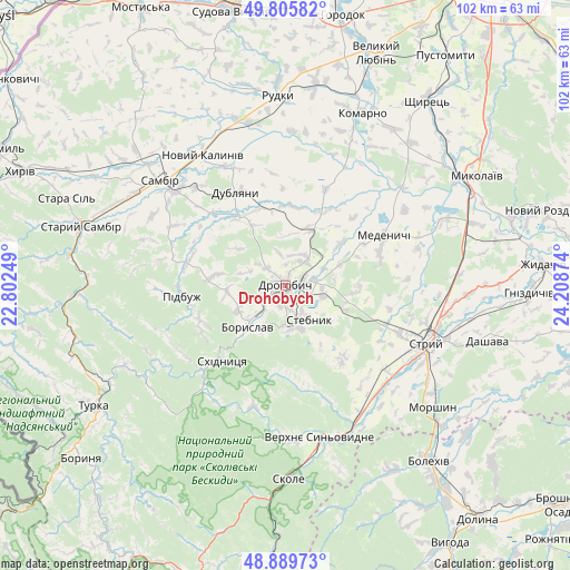
Drohobych GPS coordinates[2]
49° 20' 59.676" North, 23° 30' 20.196" East
| Map corner | latitude | longitude |
|---|---|---|
| Upper-left | 49.80582°, | 22.80249° |
| Center: | 49.34991°, | 23.50561° |
| Lower-right: | 48.88973°, | 24.20874° |
| Map W x H: | 101.9×101.9 km | = 63.3×63.3mi |
| max Lat: | 52.18903° ⇑28.3% North |
| Drohobych: | 49.34991° |
| min Lat: | ⇓71.7% South 44.39214° |
| min Long | Drohobych | max Long |
| 22.20555° | 23.50561° | 40.13222° |
| W 4.3%⇐ | ⇒95.7% E |
Elevation
Elevation of Drohobych is 301 m = 988 ft, and this is 145.2 m = 476 ft above average elevation for this country.
| Max E: |
886 m = 2907 ft | 11% |
| Drohobych | 301 m 988 ft | |
| Avg. | 155.8 m = 511 ft | |
Min E: |
-3 m = -10 ft | 89% |
See also: Drohobych elevation on elevation.city.
Geographical zone
Drohobych is located in North temperate zone (between Tropic of Cancer and the Arctic Circle). Distance of this North polar circle is 1914 km =1189.3 mi to North.| Distance of | km | miles | from Drohobych |
|---|---|---|---|
| North Pole | 4519.9 | 2808.5 | to North |
| Arctic Circle | 1914 | 1189.3 | to North |
| Tropic Cancer | 2881.3 | 1790.4 | to South |
| Equator | 5487.2 | 3409.6 | to South |


Nearby cities:
15 places around Drohobych: (largest is in red/bold)
• Boryslav
8.8 km =5.5 mi,  217°
217°
• Dublyany
18.6 km =11.6 mi,  332°
332°
• Duliby
26 km =16.2 mi,  120°
120°
• Medenychi
19.9 km =12.4 mi,  63°
63°
• Pidbuzh
18.7 km =11.6 mi,  264°
264°
• Ralivka
25.6 km =15.9 mi,  310°
310°
• Rykhtychi
5.4 km =3.4 mi,  43°
43°
• Sambir
29.1 km =18.1 mi, 310°
• Skhidnytsya
17.6 km =10.9 mi, 219°
• Stebnyk
7.5 km =4.7 mi,  145°
145°
• Stryi
27.2 km =16.9 mi,  110°
110°
• Truskavets’
8 km =5 mi,  179°
179°
• Ulychne
16.7 km =10.4 mi,  140°
140°
• Verkhnie Synevydne
28.1 km =17.5 mi,  167°
167°
• Розгирче
28.5 km =17.7 mi, 152°
Sources, notices
• [Note1] Compared only with cities in Ukraine existing in our database
• [Src1] Map data: © OpenStreetMap contributors (CC-BY-SA)
• [Src2] Other city data from geonames.org with taken over terms of usage.
• [Src3] Geographical zone / Annual Mean Temperature by Robert A. Rohde @ Wikipedia
