Stebnyk geodata
Stebnyk (Lviv) is a populated place; located in Ukraine in Europe/Kiev (GMT+3) time zone. With population of 20,087 people, there are 199 cities with bigger population in this country. Compared to other cities in Ukraine, 71.2% of cities are located further ↓South; 95.1% of cities are located further →East and 91.1% of cities have lower elevation than Stebnyk. Note1


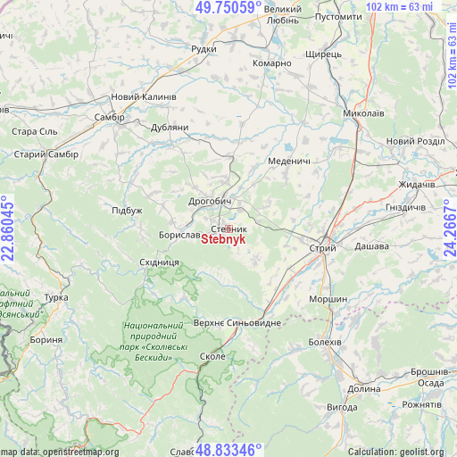
Stebnyk GPS coordinates[2]
49° 17' 38.976" North, 23° 33' 48.852" East
| Map corner | latitude | longitude |
|---|---|---|
| Upper-left | 49.75059°, | 22.86045° |
| Center: | 49.29416°, | 23.56357° |
| Lower-right: | 48.83346°, | 24.2667° |
| Map W x H: | 102×102 km | = 63.4×63.4mi |
| max Lat: | 52.18903° ⇑28.8% North |
| Stebnyk: | 49.29416° |
| min Lat: | ⇓71.2% South 44.39214° |
| min Long | Stebnyk | max Long |
| 22.20555° | 23.56357° | 40.13222° |
| W 4.9%⇐ | ⇒95.1% E |
Elevation
Elevation of Stebnyk is 314 m = 1030 ft, and this is 158.2 m = 519 ft above average elevation for this country.
| Max E: |
886 m = 2907 ft | 8.9% |
| Stebnyk | 314 m 1030 ft | |
| Avg. | 155.8 m = 511 ft | |
Min E: |
-3 m = -10 ft | 91.1% |
See also: Ukraine elevation on elevation.city.
Geographical zone
Stebnyk is located in North temperate zone (between Tropic of Cancer and the Arctic Circle). Distance of this North polar circle is 1920.2 km =1193.2 mi to North.| Distance of | km | miles | from Stebnyk |
|---|---|---|---|
| North Pole | 4526.1 | 2812.4 | to North |
| Arctic Circle | 1920.2 | 1193.2 | to North |
| Tropic Cancer | 2875.1 | 1786.5 | to South |
| Equator | 5481 | 3405.7 | to South |


Nearby cities:
15 places around Stebnyk: (largest is in red/bold)
• Boryslav
9.5 km =5.9 mi,  265°
265°
• Drohobych
7.5 km =4.7 mi,  325°
325°
• Dublyany
26 km =16.2 mi, 330°
• Duliby
19.6 km =12.2 mi,  110°
110°
• Medenychi
20.3 km =12.6 mi,  41°
41°
• Morshyn
27.1 km =16.8 mi,  124°
124°
• Pidbuzh
23.3 km =14.5 mi,  281°
281°
• Rykhtychi
10.1 km =6.3 mi,  357°
357°
• Skhidnytsya
17.1 km =10.6 mi,  244°
244°
• Skole
28.8 km =17.9 mi,  187°
187°
• Stryi
21.5 km =13.4 mi,  99°
99°
• Truskavets’
4.5 km =2.8 mi,  247°
247°
• Ulychne
9.2 km =5.7 mi,  136°
136°
• Verkhnie Synevydne
21.3 km =13.2 mi,  174°
174°
• Розгирче
21.1 km =13.1 mi,  154°
154°
Sources, notices
• [Note1] Compared only with cities in Ukraine existing in our database
• [Src1] Map data: © OpenStreetMap contributors (CC-BY-SA)
• [Src2] Other city data from geonames.org with taken over terms of usage.
• [Src3] Geographical zone / Annual Mean Temperature by Robert A. Rohde @ Wikipedia
