Bila Krynytsya geodata
Bila Krynytsya (Zhytomyr) is a populated place; located in Ukraine in Europe/Kiev (GMT+3) time zone. With population of 1,029 people, there are 1361 cities with bigger population in this country. Compared to other cities in Ukraine, 93% of cities are located further ↓South; 70.4% of cities are located further →East and 50.4% of cities have lower elevation than Bila Krynytsya. Note1


Bila Krynytsya GPS coordinates[2]
50° 38' 23.352" North, 29° 28' 13.476" East
| Map corner | latitude | longitude |
|---|---|---|
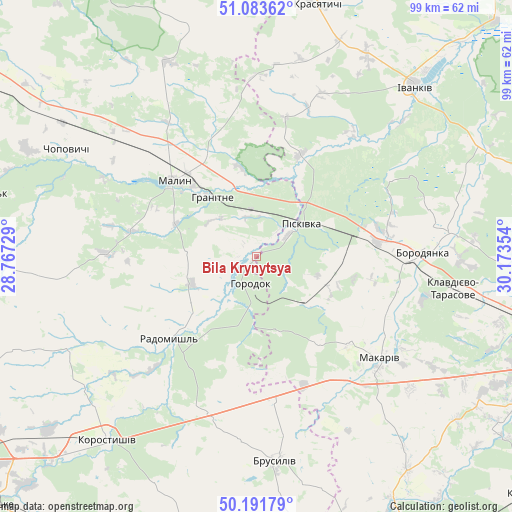
| Upper-left | 51.08362°, | 28.76729° |
| Center: | 50.63982°, | 29.47041° |
| Lower-right: | 50.19179°, | 30.17354° |
| Map W x H: | 99.2×99.2 km | = 61.6×61.6mi |
| max Lat: | 52.18903° ⇑7% North |
| Bila Krynytsya: | 50.63982° |
| min Lat: | ⇓93% South 44.39214° |
| min Long | Bila Krynytsya | max Long |
| 22.20555° | 29.47041° | 40.13222° |
| W 29.6%⇐ | ⇒70.4% E |
Elevation
Elevation of Bila Krynytsya is 137 m = 449 ft, and this is 18.8 m = 62 ft below average elevation for this country.
| Max E: |
886 m = 2907 ft | 49.6% |
| Avg. | 155.8 m = 511 ft | |
| Bila Krynytsya | 137 m = 449 ft | |
Min E: |
-3 m = -10 ft | 50.4% |
See also: Ukraine elevation on elevation.city.
Geographical zone
Bila Krynytsya is located in North temperate zone (between Tropic of Cancer and the Arctic Circle). Distance of this North polar circle is 1770.6 km =1100.2 mi to North.| Distance of | km | miles | from Bila Krynytsya |
|---|---|---|---|
| North Pole | 4376.4 | 2719.4 | to North |
| Arctic Circle | 1770.6 | 1100.2 | to North |
| Tropic Cancer | 3024.7 | 1879.5 | to South |
| Equator | 5630.6 | 3498.7 | to South |


Nearby cities:
15 places around Bila Krynytsya: (largest is in red/bold)
• Borodianka
31.7 km =19.7 mi,  88°
88°
• Brusyliv
39.7 km =24.7 mi,  174°
174°
• Chopovychi
42.3 km =26.3 mi,  300°
300°
• Holovyne
49.3 km =30.6 mi,  247°
247°
• Horodok
5 km =3.1 mi,  187°
187°
• Ivankiv
44.6 km =27.7 mi,  41°
41°
• Klavdiyevo-Tarasove
38.7 km =24 mi,  99°
99°
• Kodra
8 km =5 mi,  128°
128°
• Korostyshiv
46.3 km =28.8 mi,  219°
219°
• Makariv
31 km =19.3 mi, 129°
• Malyn
22 km =13.7 mi,  312°
312°
• Piskivka
12.1 km =7.5 mi,  60°
60°
• Radomyshl
23.4 km =14.5 mi,  226°
226°
• Stavyshche
26.9 km =16.7 mi, 171°
• Vorzel’
49.3 km =30.6 mi, 102°
Sources, notices
• [Note1] Compared only with cities in Ukraine existing in our database
• [Src1] Map data: © OpenStreetMap contributors (CC-BY-SA)
• [Src2] Other city data from geonames.org with taken over terms of usage.
• [Src3] Geographical zone / Annual Mean Temperature by Robert A. Rohde @ Wikipedia
