Makariv geodata
Makariv (Kyiv) is a seat of a second-order administrative division; located in Ukraine in Europe/Kiev (GMT+3) time zone. With population of 11,594 people, there are 316 cities with bigger population in this country. Compared to other cities in Ukraine, 90.3% of cities are located further ↓South; 68.8% of cities are located further →East and 59.7% of cities have lower elevation than Makariv. Note1


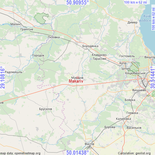
Makariv GPS coordinates[2]
50° 27' 50.688" North, 29° 48' 40.608" East
| Map corner | latitude | longitude |
|---|---|---|
| Upper-left | 50.90955°, | 29.10816° |
| Center: | 50.46408°, | 29.81128° |
| Lower-right: | 50.01438°, | 30.51441° |
| Map W x H: | 99.5×99.5 km | = 61.8×61.8mi |
| max Lat: | 52.18903° ⇑9.7% North |
| Makariv: | 50.46408° |
| min Lat: | ⇓90.3% South 44.39214° |
| min Long | Makariv | max Long |
| 22.20555° | 29.81128° | 40.13222° |
| W 31.2%⇐ | ⇒68.8% E |
Elevation
Elevation of Makariv is 168 m = 551 ft, and this is 12.2 m = 40 ft above average elevation for this country.
| Max E: |
886 m = 2907 ft | 40.3% |
| Makariv | 168 m 551 ft | |
| Avg. | 155.8 m = 511 ft | |
Min E: |
-3 m = -10 ft | 59.7% |
See also: Ukraine elevation on elevation.city.
Geographical zone
Makariv is located in North temperate zone (between Tropic of Cancer and the Arctic Circle). Distance of this North polar circle is 1790.1 km =1112.3 mi to North.| Distance of | km | miles | from Makariv |
|---|---|---|---|
| North Pole | 4396 | 2731.5 | to North |
| Arctic Circle | 1790.1 | 1112.3 | to North |
| Tropic Cancer | 3005.2 | 1867.3 | to South |
| Equator | 5611.1 | 3486.6 | to South |


Nearby cities:
15 places around Makariv: (largest is in red/bold)
• Bila Krynytsya
31 km =19.3 mi,  309°
309°
• Bobrytsya
29.6 km =18.4 mi,  115°
115°
• Borodianka
21.5 km =13.4 mi,  20°
20°
• Brusyliv
28.4 km =17.6 mi,  225°
225°
• Bucha
29.7 km =18.5 mi,  72°
72°
• Horodok
28.7 km =17.8 mi,  300°
300°
• Hostomel
34.1 km =21.2 mi, 70°
• Irpin
31.7 km =19.7 mi,  78°
78°
• Klavdiyevo-Tarasove
19.4 km =12.1 mi,  46°
46°
• Kodra
23 km =14.3 mi, 309°
• Kotsyubyns’ke
36.8 km =22.9 mi,  85°
85°
• Piskivka
28.9 km =18 mi,  332°
332°
• Stavyshche
21.3 km =13.2 mi,  250°
250°
• Vorzel’
25.8 km =16 mi, 69°
• Yasnohorodka
19.2 km =11.9 mi,  128°
128°
Sources, notices
• [Note1] Compared only with cities in Ukraine existing in our database
• [Src1] Map data: © OpenStreetMap contributors (CC-BY-SA)
• [Src2] Other city data from geonames.org with taken over terms of usage.
• [Src3] Geographical zone / Annual Mean Temperature by Robert A. Rohde @ Wikipedia
