Kodra geodata
Kodra (Kyiv) is a populated place; located in Ukraine in Europe/Kiev (GMT+3) time zone. With population of 1,685 people, there are 1173 cities with bigger population in this country. Compared to other cities in Ukraine, 92.2% of cities are located further ↓South; 69.9% of cities are located further →East and 53.3% of cities have lower elevation than Kodra. Note1


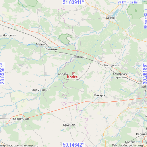
Kodra GPS coordinates[2]
50° 35' 41.568" North, 29° 33' 31.428" East
| Map corner | latitude | longitude |
|---|---|---|
| Upper-left | 51.03911°, | 28.85561° |
| Center: | 50.59488°, | 29.55873° |
| Lower-right: | 50.14642°, | 30.26186° |
| Map W x H: | 99.3×99.3 km | = 61.7×61.7mi |
| max Lat: | 52.18903° ⇑7.8% North |
| Kodra: | 50.59488° |
| min Lat: | ⇓92.2% South 44.39214° |
| min Long | Kodra | max Long |
| 22.20555° | 29.55873° | 40.13222° |
| W 30.1%⇐ | ⇒69.9% E |
Elevation
Elevation of Kodra is 146 m = 479 ft, and this is 9.8 m = 32 ft below average elevation for this country.
| Max E: |
886 m = 2907 ft | 46.7% |
| Avg. | 155.8 m = 511 ft | |
| Kodra | 146 m = 479 ft | |
Min E: |
-3 m = -10 ft | 53.3% |
See also: Ukraine elevation on elevation.city.
Geographical zone
Kodra is located in North temperate zone (between Tropic of Cancer and the Arctic Circle). Distance of this North polar circle is 1775.6 km =1103.3 mi to North.| Distance of | km | miles | from Kodra |
|---|---|---|---|
| North Pole | 4381.4 | 2722.5 | to North |
| Arctic Circle | 1775.6 | 1103.3 | to North |
| Tropic Cancer | 3019.7 | 1876.4 | to South |
| Equator | 5625.6 | 3495.6 | to South |


Nearby cities:
15 places around Kodra: (largest is in red/bold)
• Bila Krynytsya
8 km =5 mi,  308°
308°
• Borodianka
26.1 km =16.2 mi,  77°
77°
• Brusyliv
34.6 km =21.5 mi,  183°
183°
• Bucha
46.5 km =28.9 mi,  97°
97°
• Horodok
6.9 km =4.3 mi,  269°
269°
• Ivankiv
44.9 km =27.9 mi,  31°
31°
• Katyuzhanka
47 km =29.2 mi,  60°
60°
• Klavdiyevo-Tarasove
32 km =19.9 mi,  92°
92°
• Makariv
23 km =14.3 mi,  129°
129°
• Malyn
30 km =18.6 mi, 311°
• Piskivka
11.8 km =7.3 mi,  21°
21°
• Radomyshl
25.7 km =16 mi,  244°
244°
• Stavyshche
21.7 km =13.5 mi,  185°
185°
• Vorzel’
42.3 km =26.3 mi, 97°
• Yasnohorodka
42.2 km =26.2 mi, 129°
Sources, notices
• [Note1] Compared only with cities in Ukraine existing in our database
• [Src1] Map data: © OpenStreetMap contributors (CC-BY-SA)
• [Src2] Other city data from geonames.org with taken over terms of usage.
• [Src3] Geographical zone / Annual Mean Temperature by Robert A. Rohde @ Wikipedia
