Krasnokuts’k geodata
Krasnokuts’k (Kharkiv) is a seat of a second-order administrative division; located in Ukraine in Europe/Kiev (GMT+3) time zone. With population of 8,008 people, there are 444 cities with bigger population in this country. Compared to other cities in Ukraine, 84.6% of cities are located further ↓South; 82.1% of cities are located further ←West and 54% of cities have higher elevation than Krasnokuts’k. Note1


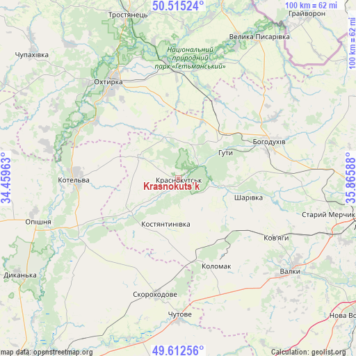
Krasnokuts’k GPS coordinates[2]
50° 3' 57.672" North, 35° 9' 45.9" East
| Map corner | latitude | longitude |
|---|---|---|
| Upper-left | 50.51524°, | 34.45963° |
| Center: | 50.06602°, | 35.16275° |
| Lower-right: | 49.61256°, | 35.86588° |
| Map W x H: | 100.4×100.4 km | = 62.4×62.4mi |
| max Lat: | 52.18903° ⇑15.4% North |
| Krasnokuts’k: | 50.06602° |
| min Lat: | ⇓84.6% South 44.39214° |
| min Long | Krasnokuts’k | max Long |
| 22.20555° | 35.16275° | 40.13222° |
| W 82.1%⇐ | ⇒17.9% E |
Elevation
Elevation of Krasnokuts’k is 122 m = 400 ft, and this is 33.8 m = 111 ft below average elevation for this country.
| Max E: |
886 m = 2907 ft | 54% |
| Avg. | 155.8 m = 511 ft | |
| Krasnokuts’k | 122 m = 400 ft | |
Min E: |
-3 m = -10 ft | 46% |
See also: Ukraine elevation on elevation.city.
Geographical zone
Krasnokuts’k is located in North temperate zone (between Tropic of Cancer and the Arctic Circle). Distance of this North polar circle is 1834.4 km =1139.8 mi to North.| Distance of | km | miles | from Krasnokuts’k |
|---|---|---|---|
| North Pole | 4440.2 | 2759 | to North |
| Arctic Circle | 1834.4 | 1139.8 | to North |
| Tropic Cancer | 2960.9 | 1839.8 | to South |
| Equator | 5566.8 | 3459 | to South |


Nearby cities:
15 places around Krasnokuts’k: (largest is in red/bold)
• Bohodukhiv
28.2 km =17.5 mi,  67°
67°
• Chutove
39.5 km =24.5 mi,  179°
179°
• Dykan’ka
52.7 km =32.7 mi,  239°
239°
• Huty
14.9 km =9.3 mi,  59°
59°
• Kolomak
27.1 km =16.8 mi,  158°
158°
• Kotel’va
28.8 km =17.9 mi,  270°
270°
• Kyrykivka
33.3 km =20.7 mi,  354°
354°
• Manchenky
50.6 km =31.4 mi,  100°
100°
• Okhtyrka
33 km =20.5 mi,  325°
325°
• Oposhnya
41.2 km =25.6 mi,  252°
252°
• Shlyakh
45.7 km =28.4 mi,  110°
110°
• Staryy Merchyk
43.6 km =27.1 mi, 102°
• Trostyanets’
48.6 km =30.2 mi,  343°
343°
• Valky
41.1 km =25.5 mi,  128°
128°
• Velyka Pysarivka
45.8 km =28.5 mi,  29°
29°
Sources, notices
• [Note1] Compared only with cities in Ukraine existing in our database
• [Src1] Map data: © OpenStreetMap contributors (CC-BY-SA)
• [Src2] Other city data from geonames.org with taken over terms of usage.
• [Src3] Geographical zone / Annual Mean Temperature by Robert A. Rohde @ Wikipedia
