Huty geodata
Huty (Kharkiv) is a populated place; located in Ukraine in Europe/Kiev (GMT+3) time zone. With population of 1,978 people, there are 1116 cities with bigger population in this country. Compared to other cities in Ukraine, 85.8% of cities are located further ↓South; 83.7% of cities are located further ←West and 54.9% of cities have higher elevation than Huty. Note1


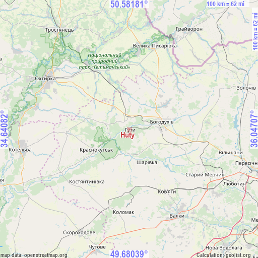
Huty GPS coordinates[2]
50° 7' 59.592" North, 35° 20' 38.184" East
| Map corner | latitude | longitude |
|---|---|---|
| Upper-left | 50.58181°, | 34.64082° |
| Center: | 50.13322°, | 35.34394° |
| Lower-right: | 49.68039°, | 36.04707° |
| Map W x H: | 100.2×100.2 km | = 62.3×62.3mi |
| max Lat: | 52.18903° ⇑14.2% North |
| Huty: | 50.13322° |
| min Lat: | ⇓85.8% South 44.39214° |
| min Long | Huty | max Long |
| 22.20555° | 35.34394° | 40.13222° |
| W 83.7%⇐ | ⇒16.3% E |
Elevation
Elevation of Huty is 120 m = 394 ft, and this is 35.8 m = 117 ft below average elevation for this country.
| Max E: |
886 m = 2907 ft | 54.9% |
| Avg. | 155.8 m = 511 ft | |
| Huty | 120 m = 394 ft | |
Min E: |
-3 m = -10 ft | 45.1% |
See also: Ukraine elevation on elevation.city.
Geographical zone
Huty is located in North temperate zone (between Tropic of Cancer and the Arctic Circle). Distance of this North polar circle is 1826.9 km =1135.2 mi to North.| Distance of | km | miles | from Huty |
|---|---|---|---|
| North Pole | 4432.8 | 2754.4 | to North |
| Arctic Circle | 1826.9 | 1135.2 | to North |
| Tropic Cancer | 2968.4 | 1844.5 | to South |
| Equator | 5574.3 | 3463.7 | to South |


Nearby cities:
15 places around Huty: (largest is in red/bold)
• Bohodukhiv
13.5 km =8.4 mi,  75°
75°
• Kolomak
32.7 km =20.3 mi,  184°
184°
• Kotel’va
42.4 km =26.3 mi,  260°
260°
• Krasnokuts’k
14.9 km =9.3 mi,  239°
239°
• Kyrykivka
30.4 km =18.9 mi,  327°
327°
• Lyubotyn
46.6 km =29 mi,  116°
116°
• Manchenky
40.5 km =25.2 mi,  114°
114°
• Okhtyrka
37.3 km =23.2 mi,  301°
301°
• Peresichna
46.9 km =29.1 mi,  104°
104°
• Shlyakh
37.9 km =23.5 mi,  127°
127°
• Staryy Merchyk
34.1 km =21.2 mi, 119°
• Trostyanets’
47.4 km =29.5 mi, 325°
• Valky
38.2 km =23.7 mi,  149°
149°
• Velyka Pysarivka
33.8 km =21 mi,  16°
16°
• Zolochiv
48.2 km =30 mi,  70°
70°
Sources, notices
• [Note1] Compared only with cities in Ukraine existing in our database
• [Src1] Map data: © OpenStreetMap contributors (CC-BY-SA)
• [Src2] Other city data from geonames.org with taken over terms of usage.
• [Src3] Geographical zone / Annual Mean Temperature by Robert A. Rohde @ Wikipedia
