Rokytne geodata
Rokytne (Kyiv) is a seat of a second-order administrative division; located in Ukraine in Europe/Kiev (GMT+3) time zone. In our database, there are 1661 cities with bigger population. Compared to other cities in Ukraine, 77.7% of cities are located further ↓South; 64.5% of cities are located further →East and 56% of cities have lower elevation than Rokytne. Note1


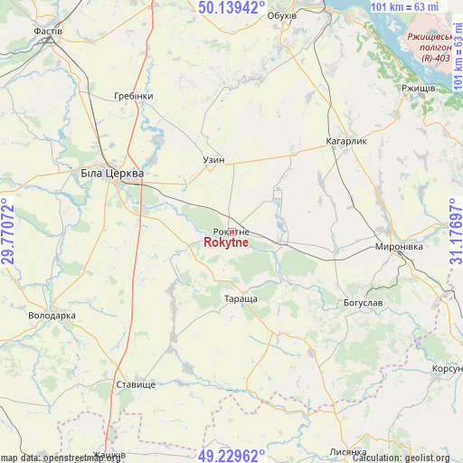
Rokytne GPS coordinates[2]
49° 41' 11.94" North, 30° 28' 25.824" East
| Map corner | latitude | longitude |
|---|---|---|
| Upper-left | 50.13942°, | 29.77072° |
| Center: | 49.68665°, | 30.47384° |
| Lower-right: | 49.22962°, | 31.17697° |
| Map W x H: | 101.2×101.2 km | = 62.9×62.9mi |
| max Lat: | 52.18903° ⇑22.3% North |
| Rokytne: | 49.68665° |
| min Lat: | ⇓77.7% South 44.39214° |
| min Long | Rokytne | max Long |
| 22.20555° | 30.47384° | 40.13222° |
| W 35.5%⇐ | ⇒64.5% E |
Elevation
Elevation of Rokytne is 155 m = 509 ft, and this is 0.80000000000001 m = 3 ft below average elevation for this country.
| Max E: |
886 m = 2907 ft | 44% |
| Avg. | 155.8 m = 511 ft | |
| Rokytne | 155 m = 509 ft | |
Min E: |
-3 m = -10 ft | 56% |
See also: Ukraine elevation on elevation.city.
Geographical zone
Rokytne is located in North temperate zone (between Tropic of Cancer and the Arctic Circle). Distance of this North polar circle is 1876.5 km =1166 mi to North.| Distance of | km | miles | from Rokytne |
|---|---|---|---|
| North Pole | 4482.4 | 2785.2 | to North |
| Arctic Circle | 1876.5 | 1166 | to North |
| Tropic Cancer | 2918.7 | 1813.6 | to South |
| Equator | 5524.6 | 3432.8 | to South |


Nearby cities:
15 places around Rokytne: (largest is in red/bold)
• Bila Tserkva
29.4 km =18.3 mi,  297°
297°
• Bohuslav
32.6 km =20.3 mi,  117°
117°
• Kaharlyk
32.1 km =19.9 mi,  52°
52°
• Kalynove
33.9 km =21.1 mi,  182°
182°
• Karapyshi
23.3 km =14.5 mi,  102°
102°
• Lobachiv
50.7 km =31.5 mi,  235°
235°
• Mirovka
29.2 km =18.1 mi,  21°
21°
• Myronivka
36.7 km =22.8 mi,  94°
94°
• Obukhiv
47.9 km =29.8 mi,  12°
12°
• Roskoshnyy
40.8 km =25.4 mi,  210°
210°
• Rzhyshchiv
51.7 km =32.1 mi, 52°
• Stavyshche
38.7 km =24 mi, 211°
• Tarashcha
14.3 km =8.9 mi,  174°
174°
• Uzyn
16.1 km =10 mi,  344°
344°
• Volodarka
44.3 km =27.5 mi,  246°
246°
Sources, notices
• [Note1] Compared only with cities in Ukraine existing in our database
• [Src1] Map data: © OpenStreetMap contributors (CC-BY-SA)
• [Src2] Other city data from geonames.org with taken over terms of usage.
• [Src3] Geographical zone / Annual Mean Temperature by Robert A. Rohde @ Wikipedia
