Volodarka geodata
Volodarka (Kyiv) is a seat of a second-order administrative division; located in Ukraine in Europe/Kiev (GMT+3) time zone. With population of 7,355 people, there are 485 cities with bigger population in this country. Compared to other cities in Ukraine, 74.9% of cities are located further ↓South; 68.3% of cities are located further →East and 61% of cities have lower elevation than Volodarka. Note1


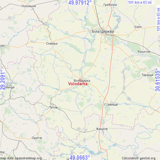
Volodarka GPS coordinates[2]
49° 31' 29.424" North, 29° 54' 43.992" East
| Map corner | latitude | longitude |
|---|---|---|
| Upper-left | 49.97912°, | 29.2091° |
| Center: | 49.52484°, | 29.91222° |
| Lower-right: | 49.0663°, | 30.61535° |
| Map W x H: | 101.5×101.5 km | = 63.1×63.1mi |
| max Lat: | 52.18903° ⇑25.1% North |
| Volodarka: | 49.52484° |
| min Lat: | ⇓74.9% South 44.39214° |
| min Long | Volodarka | max Long |
| 22.20555° | 29.91222° | 40.13222° |
| W 31.7%⇐ | ⇒68.3% E |
Elevation
Elevation of Volodarka is 172 m = 564 ft, and this is 16.2 m = 53 ft above average elevation for this country.
| Max E: |
886 m = 2907 ft | 39% |
| Volodarka | 172 m 564 ft | |
| Avg. | 155.8 m = 511 ft | |
Min E: |
-3 m = -10 ft | 61% |
See also: Ukraine elevation on elevation.city.
Geographical zone
Volodarka is located in North temperate zone (between Tropic of Cancer and the Arctic Circle). Distance of this North polar circle is 1894.5 km =1177.2 mi to North.| Distance of | km | miles | from Volodarka |
|---|---|---|---|
| North Pole | 4500.4 | 2796.4 | to North |
| Arctic Circle | 1894.5 | 1177.2 | to North |
| Tropic Cancer | 2900.7 | 1802.4 | to South |
| Equator | 5506.6 | 3421.6 | to South |


Nearby cities:
15 places around Volodarka: (largest is in red/bold)
• Bila Tserkva
34.8 km =21.6 mi,  24°
24°
• Buky
40 km =24.9 mi,  331°
331°
• Kalynove
42.1 km =26.2 mi,  112°
112°
• Lobachiv
10.6 km =6.6 mi,  187°
187°
• Orativ
46.6 km =29 mi,  216°
216°
• Pohrebyshche
47 km =29.2 mi,  264°
264°
• Rokytne
44.3 km =27.5 mi,  66°
66°
• Roskoshnyy
26.1 km =16.2 mi,  130°
130°
• Skvyra
29.1 km =18.1 mi,  322°
322°
• Stavyshche
25 km =15.5 mi, 126°
• Tarashcha
42 km =26.1 mi,  84°
84°
• Tetiiv
24.3 km =15.1 mi,  227°
227°
• Topory
45.1 km =28 mi,  288°
288°
• Uzyn
49.3 km =30.6 mi,  47°
47°
• Zhashkiv
34.2 km =21.3 mi,  155°
155°
Sources, notices
• [Note1] Compared only with cities in Ukraine existing in our database
• [Src1] Map data: © OpenStreetMap contributors (CC-BY-SA)
• [Src2] Other city data from geonames.org with taken over terms of usage.
• [Src3] Geographical zone / Annual Mean Temperature by Robert A. Rohde @ Wikipedia
