Stavyshche geodata
Stavyshche (Kyiv) is a seat of a second-order administrative division; located in Ukraine in Europe/Kiev (GMT+3) time zone. In our database, there are 1661 cities with bigger population. Compared to other cities in Ukraine, 72.6% of cities are located further ↓South; 66.8% of cities are located further →East and 70.9% of cities have lower elevation than Stavyshche. Note1


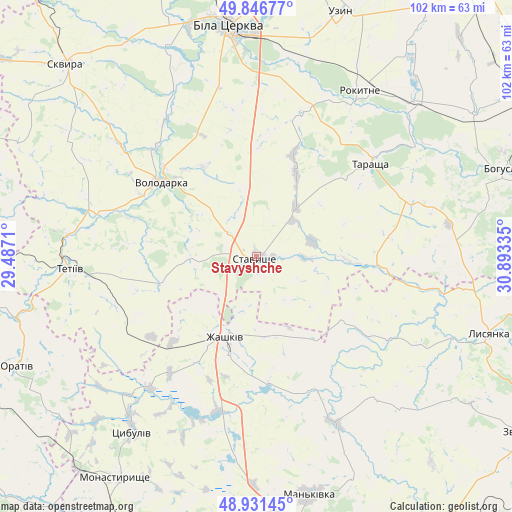
Stavyshche GPS coordinates[2]
49° 23' 28.464" North, 30° 11' 24.792" East
| Map corner | latitude | longitude |
|---|---|---|
| Upper-left | 49.84677°, | 29.4871° |
| Center: | 49.39124°, | 30.19022° |
| Lower-right: | 48.93145°, | 30.89335° |
| Map W x H: | 101.8×101.8 km | = 63.3×63.3mi |
| max Lat: | 52.18903° ⇑27.4% North |
| Stavyshche: | 49.39124° |
| min Lat: | ⇓72.6% South 44.39214° |
| min Long | Stavyshche | max Long |
| 22.20555° | 30.19022° | 40.13222° |
| W 33.2%⇐ | ⇒66.8% E |
Elevation
Elevation of Stavyshche is 210 m = 689 ft, and this is 54.2 m = 178 ft above average elevation for this country.
| Max E: |
886 m = 2907 ft | 29.1% |
| Stavyshche | 210 m 689 ft | |
| Avg. | 155.8 m = 511 ft | |
Min E: |
-3 m = -10 ft | 70.9% |
See also: Ukraine elevation on elevation.city.
Geographical zone
Stavyshche is located in North temperate zone (between Tropic of Cancer and the Arctic Circle). Distance of this North polar circle is 1909.4 km =1186.4 mi to North.| Distance of | km | miles | from Stavyshche |
|---|---|---|---|
| North Pole | 4515.3 | 2805.7 | to North |
| Arctic Circle | 1909.4 | 1186.4 | to North |
| Tropic Cancer | 2885.9 | 1793.2 | to South |
| Equator | 5491.8 | 3412.4 | to South |


Nearby cities:
15 places around Stavyshche: (largest is in red/bold)
• Bila Tserkva
46.8 km =29.1 mi,  353°
353°
• Buky
36.6 km =22.7 mi,  155°
155°
• Kalynove
18.9 km =11.7 mi,  93°
93°
• Karapyshi
51.5 km =32 mi,  57°
57°
• Lobachiv
22 km =13.7 mi,  281°
281°
• Lysianka
48.8 km =30.3 mi,  108°
108°
• Mankivka
48.7 km =30.3 mi,  167°
167°
• Rokytne
38.7 km =24 mi,  31°
31°
• Roskoshnyy
2.3 km =1.4 mi,  189°
189°
• Tarashcha
28.7 km =17.8 mi,  49°
49°
• Tetiiv
38.1 km =23.7 mi,  267°
267°
• Tsibulev
42.7 km =26.5 mi,  215°
215°
• Uzyn
51 km =31.7 mi,  18°
18°
• Volodarka
25 km =15.5 mi,  306°
306°
• Zhashkiv
17.2 km =10.7 mi,  199°
199°
Sources, notices
• [Note1] Compared only with cities in Ukraine existing in our database
• [Src1] Map data: © OpenStreetMap contributors (CC-BY-SA)
• [Src2] Other city data from geonames.org with taken over terms of usage.
• [Src3] Geographical zone / Annual Mean Temperature by Robert A. Rohde @ Wikipedia
