Berezovo geodata
Berezovo (Transcarpathia) is a populated place; located in Ukraine in Europe/Uzhgorod (GMT+3) time zone. With population of 2,885 people, there are 981 cities with bigger population in this country. Compared to other cities in Ukraine, 50% of cities are located further ↓South; 96% of cities are located further →East and 85.2% of cities have lower elevation than Berezovo. Note1


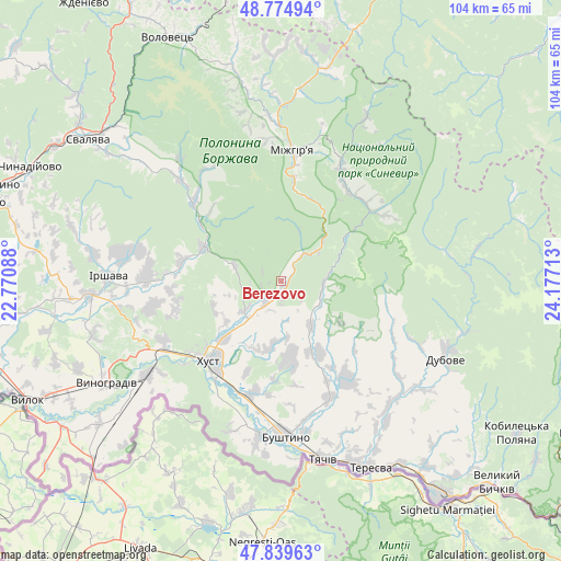
Berezovo GPS coordinates[2]
48° 18' 33.948" North, 23° 28' 26.4" East
| Map corner | latitude | longitude |
|---|---|---|
| Upper-left | 48.77494°, | 22.77088° |
| Center: | 48.30943°, | 23.474° |
| Lower-right: | 47.83963°, | 24.17713° |
| Map W x H: | 104×104 km | = 64.6×64.6mi |
| max Lat: | 52.18903° ⇑50% North |
| Berezovo: | 48.30943° |
| min Lat: | ⇓50% South 44.39214° |
| min Long | Berezovo | max Long |
| 22.20555° | 23.474° | 40.13222° |
| W 4%⇐ | ⇒96% E |
Elevation
Elevation of Berezovo is 276 m = 906 ft, and this is 120.2 m = 394 ft above average elevation for this country.
| Max E: |
886 m = 2907 ft | 14.8% |
| Berezovo | 276 m 906 ft | |
| Avg. | 155.8 m = 511 ft | |
Min E: |
-3 m = -10 ft | 85.2% |
See also: Ukraine elevation on elevation.city.
Geographical zone
Berezovo is located in North temperate zone (between Tropic of Cancer and the Arctic Circle). Distance of this North polar circle is 2029.7 km =1261.2 mi to North.| Distance of | km | miles | from Berezovo |
|---|---|---|---|
| North Pole | 4635.6 | 2880.4 | to North |
| Arctic Circle | 2029.7 | 1261.2 | to North |
| Tropic Cancer | 2765.6 | 1718.5 | to South |
| Equator | 5371.5 | 3337.7 | to South |


Nearby cities:
15 places around Berezovo: (largest is in red/bold)
• Dovhe
15.7 km =9.8 mi,  293°
293°
• Drahovo
9.9 km =6.2 mi,  145°
145°
• Horinchovo
5.2 km =3.2 mi,  214°
214°
• Iza
15 km =9.3 mi,  225°
225°
• Khust
19.4 km =12.1 mi,  221°
221°
• Kolochava
21.1 km =13.1 mi,  51°
51°
• Kopashnovo
10 km =6.2 mi,  175°
175°
• Kryva
23.3 km =14.5 mi, 229°
• Kushnytsya
21.6 km =13.4 mi,  312°
312°
• Lypcha
8.6 km =5.3 mi, 231°
• Lysychovo
24.9 km =15.5 mi,  326°
326°
• Mizhhirya
24 km =14.9 mi,  5°
5°
• Nyzhnye Selyshche
12.4 km =7.7 mi,  189°
189°
• Rokosovo
24.6 km =15.3 mi,  243°
243°
• Synevyr
22.7 km =14.1 mi,  29°
29°
Sources, notices
• [Note1] Compared only with cities in Ukraine existing in our database
• [Src1] Map data: © OpenStreetMap contributors (CC-BY-SA)
• [Src2] Other city data from geonames.org with taken over terms of usage.
• [Src3] Geographical zone / Annual Mean Temperature by Robert A. Rohde @ Wikipedia
