Synevyr geodata
Synevyr (Transcarpathia) is a populated place; located in Ukraine in Europe/Uzhgorod (GMT+3) time zone. With population of 4,623 people, there are 685 cities with bigger population in this country. Compared to other cities in Ukraine, 55% of cities are located further ↓South; 94.9% of cities are located further →East and 99.4% of cities have lower elevation than Synevyr. Note1


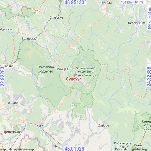
Synevyr GPS coordinates[2]
48° 29' 14.82" North, 23° 37' 32.7" East
| Map corner | latitude | longitude |
|---|---|---|
| Upper-left | 48.95133°, | 22.92263° |
| Center: | 48.48745°, | 23.62575° |
| Lower-right: | 48.01929°, | 24.32888° |
| Map W x H: | 103.6×103.6 km | = 64.4×64.4mi |
| max Lat: | 52.18903° ⇑45% North |
| Synevyr: | 48.48745° |
| min Lat: | ⇓55% South 44.39214° |
| min Long | Synevyr | max Long |
| 22.20555° | 23.62575° | 40.13222° |
| W 5.1%⇐ | ⇒94.9% E |
Elevation
Elevation of Synevyr is 630 m = 2067 ft, and this is 474.2 m = 1556 ft above average elevation for this country.
| Max E: |
886 m = 2907 ft | 0.59999999999999% |
| Synevyr | 630 m 2067 ft | |
| Avg. | 155.8 m = 511 ft | |
Min E: |
-3 m = -10 ft | 99.4% |
See also: Ukraine elevation on elevation.city.
Geographical zone
Synevyr is located in North temperate zone (between Tropic of Cancer and the Arctic Circle). Distance of this North polar circle is 2009.9 km =1248.9 mi to North.| Distance of | km | miles | from Synevyr |
|---|---|---|---|
| North Pole | 4615.8 | 2868.1 | to North |
| Arctic Circle | 2009.9 | 1248.9 | to North |
| Tropic Cancer | 2785.4 | 1730.8 | to South |
| Equator | 5391.3 | 3350 | to South |


Nearby cities:
15 places around Synevyr: (largest is in red/bold)
• Bereznyky
30.1 km =18.7 mi,  275°
275°
• Berezovo
22.7 km =14.1 mi,  209°
209°
• Dovhe
29 km =18 mi,  242°
242°
• Drahovo
28.6 km =17.8 mi,  191°
191°
• Horinchovo
27.9 km =17.3 mi, 210°
• Kolochava
8.3 km =5.2 mi,  141°
141°
• Kopashnovo
31.5 km =19.6 mi,  199°
199°
• Kushnytsya
27.6 km =17.1 mi,  258°
258°
• Lopukhiv
28.4 km =17.6 mi,  118°
118°
• Lypcha
30.9 km =19.2 mi,  215°
215°
• Lysychovo
24.8 km =15.4 mi,  272°
272°
• Mizhhirya
9.8 km =6.1 mi,  295°
295°
• Pylypets
31.6 km =19.6 mi,  307°
307°
• Synevyrska Poliana
11.8 km =7.3 mi,  23°
23°
• Verchnia Rozhanka
33.6 km =20.9 mi,  346°
346°
Sources, notices
• [Note1] Compared only with cities in Ukraine existing in our database
• [Src1] Map data: © OpenStreetMap contributors (CC-BY-SA)
• [Src2] Other city data from geonames.org with taken over terms of usage.
• [Src3] Geographical zone / Annual Mean Temperature by Robert A. Rohde @ Wikipedia
