Lysychovo geodata
Lysychovo (Transcarpathia) is a populated place; located in Ukraine in Europe/Uzhgorod (GMT+3) time zone. With population of 3,068 people, there are 921 cities with bigger population in this country. Compared to other cities in Ukraine, 55.3% of cities are located further ↓South; 96.9% of cities are located further →East and 93.4% of cities have lower elevation than Lysychovo. Note1


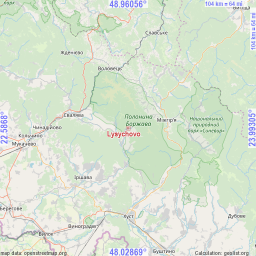
Lysychovo GPS coordinates[2]
48° 29' 48.372" North, 23° 17' 23.712" East
| Map corner | latitude | longitude |
|---|---|---|
| Upper-left | 48.96056°, | 22.5868° |
| Center: | 48.49677°, | 23.28992° |
| Lower-right: | 48.02869°, | 23.99305° |
| Map W x H: | 103.6×103.6 km | = 64.4×64.4mi |
| max Lat: | 52.18903° ⇑44.7% North |
| Lysychovo: | 48.49677° |
| min Lat: | ⇓55.3% South 44.39214° |
| min Long | Lysychovo | max Long |
| 22.20555° | 23.28992° | 40.13222° |
| W 3.1%⇐ | ⇒96.9% E |
Elevation
Elevation of Lysychovo is 337 m = 1106 ft, and this is 181.2 m = 594 ft above average elevation for this country.
| Max E: |
886 m = 2907 ft | 6.6% |
| Lysychovo | 337 m 1106 ft | |
| Avg. | 155.8 m = 511 ft | |
Min E: |
-3 m = -10 ft | 93.4% |
See also: Ukraine elevation on elevation.city.
Geographical zone
Lysychovo is located in North temperate zone (between Tropic of Cancer and the Arctic Circle). Distance of this North polar circle is 2008.8 km =1248.2 mi to North.| Distance of | km | miles | from Lysychovo |
|---|---|---|---|
| North Pole | 4614.7 | 2867.4 | to North |
| Arctic Circle | 2008.8 | 1248.2 | to North |
| Tropic Cancer | 2786.4 | 1731.4 | to South |
| Equator | 5392.3 | 3350.6 | to South |


Nearby cities:
15 places around Lysychovo: (largest is in red/bold)
• Bereznyky
5.5 km =3.4 mi,  290°
290°
• Berezovo
24.9 km =15.5 mi,  146°
146°
• Bilky
23.3 km =14.5 mi,  209°
209°
• Dovhe
14.6 km =9.1 mi,  183°
183°
• Horinchovo
27.3 km =17 mi,  156°
156°
• Irshava
27.3 km =17 mi,  222°
222°
• Kolochava
30.9 km =19.2 mi,  104°
104°
• Kushnytsya
6.7 km =4.2 mi,  200°
200°
• Lypcha
27.1 km =16.8 mi,  165°
165°
• Mizhhirya
16.2 km =10.1 mi,  78°
78°
• Nelipyno
20.3 km =12.6 mi, 290°
• Pylypets
18 km =11.2 mi,  358°
358°
• Svalyava
22.4 km =13.9 mi,  284°
284°
• Synevyr
24.8 km =15.4 mi,  92°
92°
• Volovets
25 km =15.5 mi,  342°
342°
Sources, notices
• [Note1] Compared only with cities in Ukraine existing in our database
• [Src1] Map data: © OpenStreetMap contributors (CC-BY-SA)
• [Src2] Other city data from geonames.org with taken over terms of usage.
• [Src3] Geographical zone / Annual Mean Temperature by Robert A. Rohde @ Wikipedia
