Bakhmut geodata
Bakhmut (Donetsk) is a seat of a second-order administrative division; located in Ukraine in Europe/Kiev (GMT+3) time zone. With population of 80,500 people, there are 58 cities with bigger population in this country. Compared to other cities in Ukraine, 57.8% of cities are located further ↓South; 94.3% of cities are located further ←West and 61% of cities have higher elevation than Bakhmut. Note1


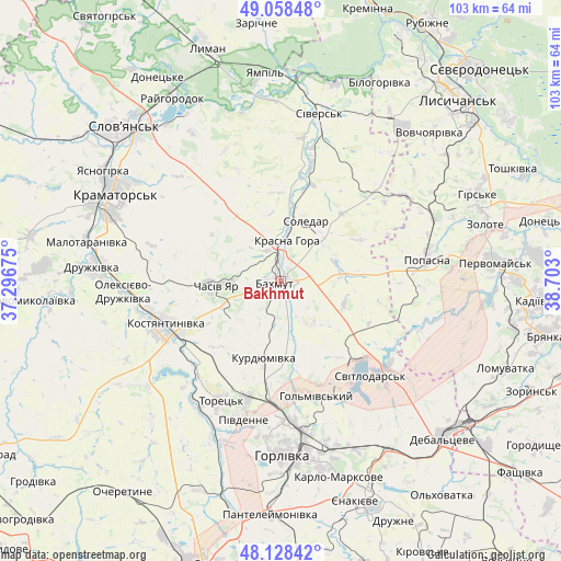
Bakhmut GPS coordinates[2]
48° 35' 44.124" North, 37° 59' 59.532" East
| Map corner | latitude | longitude |
|---|---|---|
| Upper-left | 49.05848°, | 37.29675° |
| Center: | 48.59559°, | 37.99987° |
| Lower-right: | 48.12842°, | 38.703° |
| Map W x H: | 103.4×103.4 km | = 64.2×64.2mi |
| max Lat: | 52.18903° ⇑42.2% North |
| Bakhmut: | 48.59559° |
| min Lat: | ⇓57.8% South 44.39214° |
| min Long | Bakhmut | max Long |
| 22.20555° | 37.99987° | 40.13222° |
| W 94.3%⇐ | ⇒5.7% E |
Elevation
Elevation of Bakhmut is 102 m = 335 ft, and this is 53.8 m = 177 ft below average elevation for this country.
| Max E: |
886 m = 2907 ft | 61% |
| Avg. | 155.8 m = 511 ft | |
| Bakhmut | 102 m = 335 ft | |
Min E: |
-3 m = -10 ft | 39% |
See also: Bakhmut elevation on elevation.city.
Geographical zone
Bakhmut is located in North temperate zone (between Tropic of Cancer and the Arctic Circle). Distance of this North polar circle is 1997.9 km =1241.4 mi to North.| Distance of | km | miles | from Bakhmut |
|---|---|---|---|
| North Pole | 4603.7 | 2860.6 | to North |
| Arctic Circle | 1997.9 | 1241.4 | to North |
| Tropic Cancer | 2797.4 | 1738.2 | to South |
| Equator | 5403.3 | 3357.5 | to South |


Nearby cities:
15 places around Bakhmut: (largest is in red/bold)
• Chasiv Yar
10.5 km =6.5 mi,  268°
268°
• Druzhkivka
33.1 km =20.6 mi,  276°
276°
• Horlivka
29.2 km =18.1 mi,  172°
172°
• Kostyantynivka
22.8 km =14.2 mi,  250°
250°
• Kramators’k
35.5 km =22.1 mi,  293°
293°
• Krasnotorka
35.6 km =22.1 mi, 285°
• Kryva Luka
31.7 km =19.7 mi,  347°
347°
• Luhans’ke
25.5 km =15.8 mi,  130°
130°
• Popasna
28.1 km =17.5 mi,  81°
81°
• Shcherbynivka
27.1 km =16.8 mi,  214°
214°
• Sivers’k
31.1 km =19.3 mi,  13°
13°
• Soledar
11.4 km =7.1 mi,  35°
35°
• Svetlodarsk
24.4 km =15.2 mi,  137°
137°
• Toretsk
24.6 km =15.3 mi, 207°
• Vuhlehirs’k
37.2 km =23.1 mi,  147°
147°
Sources, notices
• [Note1] Compared only with cities in Ukraine existing in our database
• [Src1] Map data: © OpenStreetMap contributors (CC-BY-SA)
• [Src2] Other city data from geonames.org with taken over terms of usage.
• [Src3] Geographical zone / Annual Mean Temperature by Robert A. Rohde @ Wikipedia
