Popasna geodata
Popasna (Luhansk) is a seat of a second-order administrative division; located in Ukraine in Europe/Zaporozhye (GMT+3) time zone. With population of 25,442 people, there are 164 cities with bigger population in this country. Compared to other cities in Ukraine, 58.4% of cities are located further ↓South; 96.3% of cities are located further ←West and 79.2% of cities have lower elevation than Popasna. Note1


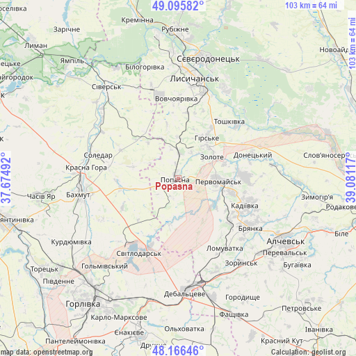
Popasna GPS coordinates[2]
48° 37' 59.808" North, 38° 22' 40.944" East
| Map corner | latitude | longitude |
|---|---|---|
| Upper-left | 49.09582°, | 37.67492° |
| Center: | 48.63328°, | 38.37804° |
| Lower-right: | 48.16646°, | 39.08117° |
| Map W x H: | 103.3×103.3 km | = 64.2×64.2mi |
| max Lat: | 52.18903° ⇑41.6% North |
| Popasna: | 48.63328° |
| min Lat: | ⇓58.4% South 44.39214° |
| min Long | Popasna | max Long |
| 22.20555° | 38.37804° | 40.13222° |
| W 96.3%⇐ | ⇒3.7% E |
Elevation
Elevation of Popasna is 243 m = 797 ft, and this is 87.2 m = 286 ft above average elevation for this country.
| Max E: |
886 m = 2907 ft | 20.8% |
| Popasna | 243 m 797 ft | |
| Avg. | 155.8 m = 511 ft | |
Min E: |
-3 m = -10 ft | 79.2% |
See also: Ukraine elevation on elevation.city.
Geographical zone
Popasna is located in North temperate zone (between Tropic of Cancer and the Arctic Circle). Distance of this North polar circle is 1993.7 km =1238.8 mi to North.| Distance of | km | miles | from Popasna |
|---|---|---|---|
| North Pole | 4599.5 | 2858 | to North |
| Arctic Circle | 1993.7 | 1238.8 | to North |
| Tropic Cancer | 2801.6 | 1740.8 | to South |
| Equator | 5407.5 | 3360.1 | to South |


Nearby cities:
15 places around Popasna: (largest is in red/bold)
• Bakhmut
28.1 km =17.5 mi,  261°
261°
• Bayrachky
31.5 km =19.6 mi,  148°
148°
• Bryanka
25.6 km =15.9 mi,  122°
122°
• Debal’tseve
32.6 km =20.3 mi,  176°
176°
• Hirs’ke
14.2 km =8.8 mi,  37°
37°
• Kadiyivka
20.8 km =12.9 mi,  110°
110°
• Kirovs’k
19.5 km =12.1 mi,  88°
88°
• Luhans’ke
22.5 km =14 mi,  202°
202°
• Lysychans’k
30.6 km =19 mi,  8°
8°
• Pervomays’k
12.5 km =7.8 mi, 91°
• Soledar
21.8 km =13.5 mi,  283°
283°
• Svetlodarsk
24.9 km =15.5 mi,  207°
207°
• Toshkivka
21.9 km =13.6 mi, 42°
• Voronove
32.7 km =20.3 mi,  25°
25°
• Zoryns’k
30.5 km =19 mi,  143°
143°
Sources, notices
• [Note1] Compared only with cities in Ukraine existing in our database
• [Src1] Map data: © OpenStreetMap contributors (CC-BY-SA)
• [Src2] Other city data from geonames.org with taken over terms of usage.
• [Src3] Geographical zone / Annual Mean Temperature by Robert A. Rohde @ Wikipedia
