Soledar geodata
Soledar (Donetsk) is a populated place; located in Ukraine in Europe/Kiev (GMT+3) time zone. With population of 12,662 people, there are 293 cities with bigger population in this country. Compared to other cities in Ukraine, 59.9% of cities are located further ↓South; 94.9% of cities are located further ←West and 67.7% of cities have higher elevation than Soledar. Note1


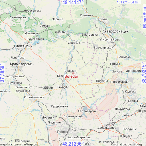
Soledar GPS coordinates[2]
48° 40' 45.66" North, 38° 5' 20.472" East
| Map corner | latitude | longitude |
|---|---|---|
| Upper-left | 49.14147°, | 37.3859° |
| Center: | 48.67935°, | 38.08902° |
| Lower-right: | 48.21296°, | 38.79215° |
| Map W x H: | 103.2×103.2 km | = 64.1×64.1mi |
| max Lat: | 52.18903° ⇑40.1% North |
| Soledar: | 48.67935° |
| min Lat: | ⇓59.9% South 44.39214° |
| min Long | Soledar | max Long |
| 22.20555° | 38.08902° | 40.13222° |
| W 94.9%⇐ | ⇒5.1% E |
Elevation
Elevation of Soledar is 82 m = 269 ft, and this is 73.8 m = 242 ft below average elevation for this country.
| Max E: |
886 m = 2907 ft | 67.7% |
| Avg. | 155.8 m = 511 ft | |
| Soledar | 82 m = 269 ft | |
Min E: |
-3 m = -10 ft | 32.3% |
See also: Ukraine elevation on elevation.city.
Geographical zone
Soledar is located in North temperate zone (between Tropic of Cancer and the Arctic Circle). Distance of this North polar circle is 1988.5 km =1235.6 mi to North.| Distance of | km | miles | from Soledar |
|---|---|---|---|
| North Pole | 4594.4 | 2854.8 | to North |
| Arctic Circle | 1988.5 | 1235.6 | to North |
| Tropic Cancer | 2806.7 | 1744 | to South |
| Equator | 5412.6 | 3363.2 | to South |


Nearby cities:
15 places around Soledar: (largest is in red/bold)
• Bakhmut
11.4 km =7.1 mi,  215°
215°
• Bilohorivka
29.7 km =18.5 mi,  23°
23°
• Chasiv Yar
19.5 km =12.1 mi,  240°
240°
• Hirs’ke
30.4 km =18.9 mi,  78°
78°
• Kostyantynivka
32.8 km =20.4 mi, 239°
• Kryva Luka
25.5 km =15.8 mi,  327°
327°
• Luhans’ke
28.9 km =18 mi,  153°
153°
• Lysychans’k
36 km =22.4 mi,  45°
45°
• Pervomays’k
34.2 km =21.3 mi,  99°
99°
• Popasna
21.8 km =13.5 mi, 103°
• Serebryanka
26.9 km =16.7 mi,  7°
7°
• Sivers’k
20.9 km =13 mi,  2°
2°
• Svetlodarsk
29 km =18 mi,  160°
160°
• Toretsk
35.9 km =22.3 mi,  209°
209°
• Yampil’
30.1 km =18.7 mi,  341°
341°
Sources, notices
• [Note1] Compared only with cities in Ukraine existing in our database
• [Src1] Map data: © OpenStreetMap contributors (CC-BY-SA)
• [Src2] Other city data from geonames.org with taken over terms of usage.
• [Src3] Geographical zone / Annual Mean Temperature by Robert A. Rohde @ Wikipedia
