Lanivtsi geodata
Lanivtsi (Ternopil) is a seat of a second-order administrative division; located in Ukraine in Europe/Kiev (GMT+3) time zone. With population of 8,357 people, there are 423 cities with bigger population in this country. Compared to other cities in Ukraine, 81.1% of cities are located further ↓South; 80.9% of cities are located further →East and 84.8% of cities have lower elevation than Lanivtsi. Note1


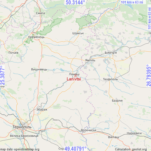
Lanivtsi GPS coordinates[2]
49° 51' 47.808" North, 26° 5' 26.952" East
| Map corner | latitude | longitude |
|---|---|---|
| Upper-left | 50.3144°, | 25.3877° |
| Center: | 49.86328°, | 26.09082° |
| Lower-right: | 49.40791°, | 26.79395° |
| Map W x H: | 100.8×100.8 km | = 62.6×62.6mi |
| max Lat: | 52.18903° ⇑18.9% North |
| Lanivtsi: | 49.86328° |
| min Lat: | ⇓81.1% South 44.39214° |
| min Long | Lanivtsi | max Long |
| 22.20555° | 26.09082° | 40.13222° |
| W 19.1%⇐ | ⇒80.9% E |
Elevation
Elevation of Lanivtsi is 272 m = 892 ft, and this is 116.2 m = 381 ft above average elevation for this country.
| Max E: |
886 m = 2907 ft | 15.2% |
| Lanivtsi | 272 m 892 ft | |
| Avg. | 155.8 m = 511 ft | |
Min E: |
-3 m = -10 ft | 84.8% |
See also: Ukraine elevation on elevation.city.
Geographical zone
Lanivtsi is located in North temperate zone (between Tropic of Cancer and the Arctic Circle). Distance of this North polar circle is 1856.9 km =1153.8 mi to North.| Distance of | km | miles | from Lanivtsi |
|---|---|---|---|
| North Pole | 4462.8 | 2773.1 | to North |
| Arctic Circle | 1856.9 | 1153.8 | to North |
| Tropic Cancer | 2938.4 | 1825.8 | to South |
| Equator | 5544.3 | 3445.1 | to South |


Nearby cities:
15 places around Lanivtsi: (largest is in red/bold)
• Bazaliya
32.2 km =20 mi,  121°
121°
• Kremenets
36.9 km =22.9 mi,  314°
314°
• Lyakhovtsy
28.7 km =17.8 mi,  57°
57°
• Petrikov
52.1 km =32.4 mi,  224°
224°
• Pidvolochysk
36.7 km =22.8 mi,  173°
173°
• Pochaiv
44.3 km =27.5 mi,  290°
290°
• Shumsk
28.8 km =17.9 mi,  3°
3°
• Skalat
49.1 km =30.5 mi,  189°
189°
• Smyga
47.8 km =29.7 mi,  330°
330°
• Teofipol
23.4 km =14.5 mi,  96°
96°
• Ternopil
49.9 km =31 mi,  226°
226°
• Velikiye Borki
44.7 km =27.8 mi,  212°
212°
• Volochysk
37.3 km =23.2 mi, 166°
• Zaliztsi
52.1 km =32.4 mi,  261°
261°
• Zbarazh
31.7 km =19.7 mi, 225°
Sources, notices
• [Note1] Compared only with cities in Ukraine existing in our database
• [Src1] Map data: © OpenStreetMap contributors (CC-BY-SA)
• [Src2] Other city data from geonames.org with taken over terms of usage.
• [Src3] Geographical zone / Annual Mean Temperature by Robert A. Rohde @ Wikipedia
