Brody geodata
Brody (Lviv) is a seat of a second-order administrative division; located in Ukraine in Europe/Kiev (GMT+3) time zone. With population of 23,239 people, there are 178 cities with bigger population in this country. Compared to other cities in Ukraine, 85% of cities are located further ↓South; 85.3% of cities are located further →East and 74.4% of cities have lower elevation than Brody. Note1


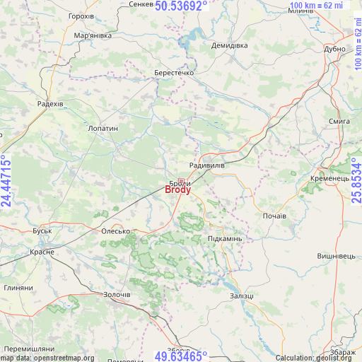
Brody GPS coordinates[2]
50° 5' 16.476" North, 25° 9' 0.972" East
| Map corner | latitude | longitude |
|---|---|---|
| Upper-left | 50.53692°, | 24.44715° |
| Center: | 50.08791°, | 25.15027° |
| Lower-right: | 49.63465°, | 25.8534° |
| Map W x H: | 100.3×100.3 km | = 62.3×62.3mi |
| max Lat: | 52.18903° ⇑15% North |
| Brody: | 50.08791° |
| min Lat: | ⇓85% South 44.39214° |
| min Long | Brody | max Long |
| 22.20555° | 25.15027° | 40.13222° |
| W 14.7%⇐ | ⇒85.3% E |
Elevation
Elevation of Brody is 223 m = 732 ft, and this is 67.2 m = 220 ft above average elevation for this country.
| Max E: |
886 m = 2907 ft | 25.6% |
| Brody | 223 m 732 ft | |
| Avg. | 155.8 m = 511 ft | |
Min E: |
-3 m = -10 ft | 74.4% |
See also: Ukraine elevation on elevation.city.
Geographical zone
Brody is located in North temperate zone (between Tropic of Cancer and the Arctic Circle). Distance of this North polar circle is 1831.9 km =1138.3 mi to North.| Distance of | km | miles | from Brody |
|---|---|---|---|
| North Pole | 4437.8 | 2757.5 | to North |
| Arctic Circle | 1831.9 | 1138.3 | to North |
| Tropic Cancer | 2963.3 | 1841.3 | to South |
| Equator | 5569.3 | 3460.6 | to South |


Nearby cities:
15 places around Brody: (largest is in red/bold)
• Berestechko
30.4 km =18.9 mi,  354°
354°
• Bus’k
40.8 km =25.4 mi,  250°
250°
• Demydivka
40.1 km =24.9 mi,  19°
19°
• Krasne
42.9 km =26.7 mi,  243°
243°
• Kremenets
41 km =25.5 mi,  88°
88°
• Kulykiv
34.6 km =21.5 mi,  316°
316°
• Lopatyn
26.1 km =16.2 mi,  304°
304°
• Olesko
23.1 km =14.4 mi,  232°
232°
• Pidhirtsi
19.9 km =12.4 mi,  217°
217°
• Pidkamin’
19.8 km =12.3 mi,  142°
142°
• Pochaiv
27.4 km =17 mi,  109°
109°
• Radekhiv
42.1 km =26.2 mi, 300°
• Radyvyliv
8.9 km =5.5 mi,  58°
58°
• Zaliztsi
36.6 km =22.7 mi,  154°
154°
• Zolochiv
36.3 km =22.6 mi,  210°
210°
Sources, notices
• [Note1] Compared only with cities in Ukraine existing in our database
• [Src1] Map data: © OpenStreetMap contributors (CC-BY-SA)
• [Src2] Other city data from geonames.org with taken over terms of usage.
• [Src3] Geographical zone / Annual Mean Temperature by Robert A. Rohde @ Wikipedia
