Buhweju geodata
Buhweju (Western Region) is a seat of a second-order administrative division; located in Uganda in Africa/Kampala (GMT+3) time zone. In our database, there are 80 cities with bigger population. Compared to other cities in Uganda, 84.9% of cities are located further ↑North; 88.4% of cities are located further →East and 95.9% of cities have lower elevation than Buhweju. Note1
Administrative division(s):
- Level 1: Western Region
- Level 2: Buhweju District
- Level 3: Buhweju County
- Level 4: Burere


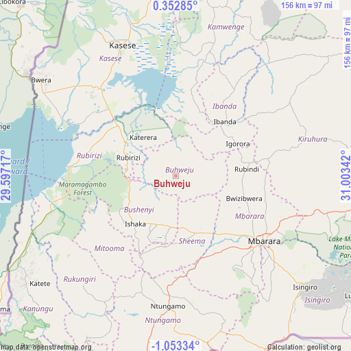
Buhweju GPS coordinates[2]
0° 21' 0.972" South, 30° 18' 1.044" East
| Map corner | latitude | longitude |
|---|---|---|
| Upper-left | 0.35285°, | 29.59717° |
| Center: | -0.35027°, | 30.30029° |
| Lower-right: | -1.05334°, | 31.00342° |
| Map W x H: | 156.4×156.4 km | = 97.2×97.2mi |
| max Lat: | 3.66088° ⇑84.9% North |
| Buhweju: | -0.35027° |
| min Lat: | ⇓15.1% South -1.28538° |
| min Long | Buhweju | max Long |
| 29.65° | 30.30029° | 34.95° |
| W 11.6%⇐ | ⇒88.4% E |
Elevation
Elevation of Buhweju is 1840 m = 6037 ft, and this is 581 m = 1906 ft above average elevation for this country.
| Max E: |
4129 m = 13547 ft | 4.1% |
| Buhweju | 1840 m 6037 ft | |
| Avg. | 1259 m = 4131 ft | |
Min E: |
622 m = 2041 ft | 95.9% |
See also: Uganda elevation on elevation.city.
Geographical zone
Buhweju is located in South Torrid zone (between Equator and Tropic of Capricorn). Distance of Equator is 38.9 km =24.2 mi to North.| Distance of | km | miles | from Buhweju |
|---|---|---|---|
| Equator | 38.9 | 24.2 | to North |
| Tropic Capricorn | 2567 | 1595.1 | to South |
| Antarctic Circle | 7362.2 | 4574.7 | to South |
| South Pole | 9968.1 | 6193.9 | to South |


Nearby cities:
15 places around Buhweju: (largest is in red/bold)
• Bushenyi
24.3 km =15.1 mi,  211°
211°
• Bwizibwera
45.3 km =28.1 mi,  126°
126°
• Ibanda
32.4 km =20.1 mi,  42°
42°
• Kamwenge
62.1 km =38.6 mi,  15°
15°
• Kasese
64 km =39.8 mi,  337°
337°
• Kibingo
34.2 km =21.3 mi,  153°
153°
• Kilembe
68.9 km =42.8 mi,  332°
332°
• Kiruhura
62.9 km =39.1 mi,  74°
74°
• Mbarara
47.9 km =29.8 mi, 126°
• Mitoma
45.1 km =28 mi, 214°
• Nsika
14.6 km =9.1 mi,  93°
93°
• Ntungamo
59 km =36.7 mi,  183°
183°
• Nyachera
62.5 km =38.8 mi,  168°
168°
• Rubirizi
19.4 km =12.1 mi,  287°
287°
• Rukungiri
67.6 km =42 mi,  216°
216°
Sources, notices
• [Note1] Compared only with cities in Uganda existing in our database
• [Src1] Map data: © OpenStreetMap contributors (CC-BY-SA)
• [Src2] Other city data from geonames.org with taken over terms of usage.
• [Src3] Geographical zone / Annual Mean Temperature by Robert A. Rohde @ Wikipedia
