Kibingo geodata
Kibingo (Western Region) is a seat of a second-order administrative division; located in Uganda in Africa/Kampala (GMT+3) time zone. In our database, there are 80 cities with bigger population. Compared to other cities in Uganda, 91.8% of cities are located further ↑North; 86.3% of cities are located further →East and 84.2% of cities have lower elevation than Kibingo. Note1
Administrative division(s):
- Level 1: Western Region
- Level 2: Sheema District
- Level 3: Sheema
- Level 4: Kagango Sub-County


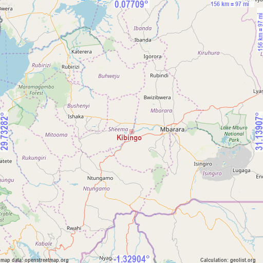
Kibingo GPS coordinates[2]
0° 37' 33.672" South, 30° 26' 9.384" East
| Map corner | latitude | longitude |
|---|---|---|
| Upper-left | 0.07709°, | 29.73282° |
| Center: | -0.62602°, | 30.43594° |
| Lower-right: | -1.32904°, | 31.13907° |
| Map W x H: | 156.3×156.4 km | = 97.1×97.2mi |
| max Lat: | 3.66088° ⇑91.8% North |
| Kibingo: | -0.62602° |
| min Lat: | ⇓8.2% South -1.28538° |
| min Long | Kibingo | max Long |
| 29.65° | 30.43594° | 34.95° |
| W 13.7%⇐ | ⇒86.3% E |
Elevation
Elevation of Kibingo is 1425 m = 4675 ft, and this is 166 m = 545 ft above average elevation for this country.
| Max E: |
4129 m = 13547 ft | 15.8% |
| Kibingo | 1425 m 4675 ft | |
| Avg. | 1259 m = 4131 ft | |
Min E: |
622 m = 2041 ft | 84.2% |
See also: Uganda elevation on elevation.city.
Geographical zone
Kibingo is located in South Torrid zone (between Equator and Tropic of Capricorn). Distance of Equator is 69.6 km =43.2 mi to North.| Distance of | km | miles | from Kibingo |
|---|---|---|---|
| Equator | 69.6 | 43.2 | to North |
| Tropic Capricorn | 2536.3 | 1576 | to South |
| Antarctic Circle | 7331.6 | 4555.6 | to South |
| South Pole | 9937.5 | 6174.9 | to South |


Nearby cities:
15 places around Kibingo: (largest is in red/bold)
• Buhweju
34.2 km =21.3 mi,  333°
333°
• Bushenyi
29.5 km =18.3 mi,  289°
289°
• Bwizibwera
21.8 km =13.5 mi,  79°
79°
• Ibanda
55.1 km =34.2 mi,  6°
6°
• Isingiro
51.5 km =32 mi,  121°
121°
• Kanungu
80.7 km =50.1 mi,  242°
242°
• Kihihi
82.6 km =51.3 mi,  274°
274°
• Kiruhura
65.9 km =40.9 mi,  43°
43°
• Mbarara
23.8 km =14.8 mi, 84°
• Mitoma
41.2 km =25.6 mi,  260°
260°
• Nsika
29.8 km =18.5 mi,  359°
359°
• Ntungamo
34 km =21.1 mi,  214°
214°
• Nyachera
30.5 km =19 mi,  184°
184°
• Rubirizi
49.5 km =30.8 mi,  317°
317°
• Rukungiri
59.9 km =37.2 mi,  246°
246°
Sources, notices
• [Note1] Compared only with cities in Uganda existing in our database
• [Src1] Map data: © OpenStreetMap contributors (CC-BY-SA)
• [Src2] Other city data from geonames.org with taken over terms of usage.
• [Src3] Geographical zone / Annual Mean Temperature by Robert A. Rohde @ Wikipedia
