Bwizibwera geodata
Bwizibwera (Western Region) is a populated place; located in Uganda in Africa/Kampala (GMT+3) time zone. With population of 79,157 people, there are 5 cities with bigger population in this country. Compared to other cities in Uganda, 89% of cities are located further ↑North; 82.9% of cities are located further →East and 82.2% of cities have lower elevation than Bwizibwera. Note1
Administrative division(s):
- Level 1: Western Region
- Level 2: Mbarara District
- Level 3: Mbarara Municipality
- Level 4: Kamukuzi Division


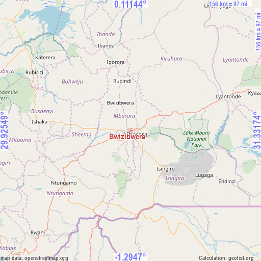
Bwizibwera GPS coordinates[2]
0° 35' 30.012" South, 30° 37' 42.996" East
| Map corner | latitude | longitude |
|---|---|---|
| Upper-left | 0.11144°, | 29.92549° |
| Center: | -0.59167°, | 30.62861° |
| Lower-right: | -1.2947°, | 31.33174° |
| Map W x H: | 156.3×156.4 km | = 97.1×97.2mi |
| max Lat: | 3.66088° ⇑89% North |
| Bwizibwera: | -0.59167° |
| min Lat: | ⇓11% South -1.28538° |
| min Long | Bwizibwera | max Long |
| 29.65° | 30.62861° | 34.95° |
| W 17.1%⇐ | ⇒82.9% E |
Elevation
Elevation of Bwizibwera is 1415 m = 4642 ft, and this is 156 m = 512 ft above average elevation for this country.
| Max E: |
4129 m = 13547 ft | 17.8% |
| Bwizibwera | 1415 m 4642 ft | |
| Avg. | 1259 m = 4131 ft | |
Min E: |
622 m = 2041 ft | 82.2% |
See also: Bwizibwera elevation on elevation.city.
Geographical zone
Bwizibwera is located in South Torrid zone (between Equator and Tropic of Capricorn). Distance of Equator is 65.8 km =40.9 mi to North.| Distance of | km | miles | from Bwizibwera |
|---|---|---|---|
| Equator | 65.8 | 40.9 | to North |
| Tropic Capricorn | 2540.1 | 1578.3 | to South |
| Antarctic Circle | 7335.4 | 4558 | to South |
| South Pole | 9941.3 | 6177.2 | to South |


Nearby cities:
15 places around Bwizibwera: (largest is in red/bold)
• Buhweju
45.3 km =28.1 mi,  306°
306°
• Bushenyi
49.6 km =30.8 mi,  277°
277°
• Byakabanda
88.1 km =54.7 mi,  100°
100°
• Ibanda
53 km =32.9 mi,  343°
343°
• Isingiro
38.1 km =23.7 mi,  143°
143°
• Kibingo
21.8 km =13.5 mi,  259°
259°
• Kiruhura
50.1 km =31.1 mi,  28°
28°
• Lyantonde
62.4 km =38.8 mi,  70°
70°
• Mbarara
2.6 km =1.6 mi,  123°
123°
• Mitoma
63 km =39.1 mi, 260°
• Nsika
34 km =21.1 mi,  319°
319°
• Ntungamo
51.6 km =32.1 mi,  231°
231°
• Nyachera
41.6 km =25.8 mi,  214°
214°
• Rubirizi
63.9 km =39.7 mi,  300°
300°
• Rukungiri
81.2 km =50.5 mi,  250°
250°
Sources, notices
• [Note1] Compared only with cities in Uganda existing in our database
• [Src1] Map data: © OpenStreetMap contributors (CC-BY-SA)
• [Src2] Other city data from geonames.org with taken over terms of usage.
• [Src3] Geographical zone / Annual Mean Temperature by Robert A. Rohde @ Wikipedia
