Bushenyi geodata
Bushenyi (Western Region) is a seat of a second-order administrative division; located in Uganda in Africa/Kampala (GMT+3) time zone. In our database, there are 80 cities with bigger population. Compared to other cities in Uganda, 87.7% of cities are located further ↑North; 91.1% of cities are located further →East and 91.1% of cities have lower elevation than Bushenyi. Note1
Administrative division(s):
- Level 1: Western Region
- Level 2: Bushenyi District
- Level 3: Igara
- Level 4: Nyakabirizi Division


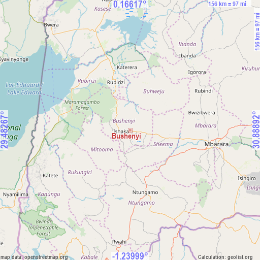
Bushenyi GPS coordinates[2]
0° 32' 13.02" South, 30° 11' 8.844" East
| Map corner | latitude | longitude |
|---|---|---|
| Upper-left | 0.16617°, | 29.48267° |
| Center: | -0.53695°, | 30.18579° |
| Lower-right: | -1.23999°, | 30.88892° |
| Map W x H: | 156.4×156.4 km | = 97.2×97.2mi |
| max Lat: | 3.66088° ⇑87.7% North |
| Bushenyi: | -0.53695° |
| min Lat: | ⇓12.3% South -1.28538° |
| min Long | Bushenyi | max Long |
| 29.65° | 30.18579° | 34.95° |
| W 8.9%⇐ | ⇒91.1% E |
Elevation
Elevation of Bushenyi is 1607 m = 5272 ft, and this is 348 m = 1142 ft above average elevation for this country.
| Max E: |
4129 m = 13547 ft | 8.9% |
| Bushenyi | 1607 m 5272 ft | |
| Avg. | 1259 m = 4131 ft | |
Min E: |
622 m = 2041 ft | 91.1% |
See also: Uganda elevation on elevation.city.
Geographical zone
Bushenyi is located in South Torrid zone (between Equator and Tropic of Capricorn). Distance of Equator is 59.7 km =37.1 mi to North.| Distance of | km | miles | from Bushenyi |
|---|---|---|---|
| Equator | 59.7 | 37.1 | to North |
| Tropic Capricorn | 2546.2 | 1582.1 | to South |
| Antarctic Circle | 7341.5 | 4561.8 | to South |
| South Pole | 9947.4 | 6181 | to South |


Nearby cities:
15 places around Bushenyi: (largest is in red/bold)
• Buhweju
24.3 km =15.1 mi,  31°
31°
• Bwizibwera
49.6 km =30.8 mi,  97°
97°
• Ibanda
56.6 km =35.2 mi,  37°
37°
• Isingiro
80.6 km =50.1 mi,  117°
117°
• Kanungu
64.2 km =39.9 mi,  223°
223°
• Kibingo
29.5 km =18.3 mi,  109°
109°
• Kihihi
54.7 km =34 mi,  266°
266°
• Mbarara
52 km =32.3 mi, 98°
• Mitoma
20.8 km =12.9 mi, 218°
• Nsika
33.8 km =21 mi,  53°
53°
• Ntungamo
39.1 km =24.3 mi,  167°
167°
• Ntungamo
70.9 km =44.1 mi,  237°
237°
• Nyachera
47.8 km =29.7 mi,  147°
147°
• Rubirizi
27.1 km =16.8 mi,  347°
347°
• Rukungiri
43.3 km =26.9 mi, 218°
Sources, notices
• [Note1] Compared only with cities in Uganda existing in our database
• [Src1] Map data: © OpenStreetMap contributors (CC-BY-SA)
• [Src2] Other city data from geonames.org with taken over terms of usage.
• [Src3] Geographical zone / Annual Mean Temperature by Robert A. Rohde @ Wikipedia
