Kamwenge geodata
Kamwenge (Western Region) is a seat of a second-order administrative division; located in Uganda in Africa/Kampala (GMT+3) time zone. With population of 17,169 people, there are 42 cities with bigger population in this country. Compared to other cities in Uganda, 76.7% of cities are located further ↑North; 85.6% of cities are located further →East and 67.8% of cities have lower elevation than Kamwenge. Note1
Administrative division(s):
- Level 1: Western Region
- Level 2: Kamwenge District
- Level 3: Kibale County
- Level 4: Kamwenge Town Council Sub-County


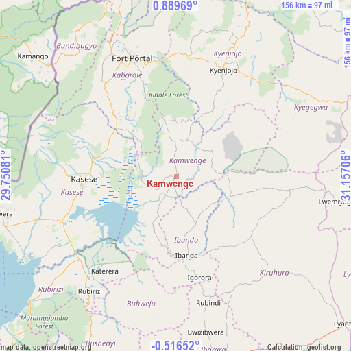
Kamwenge GPS coordinates[2]
0° 11' 11.76" North, 30° 27' 14.148" East
| Map corner | latitude | longitude |
|---|---|---|
| Upper-left | 0.88969°, | 29.75081° |
| Center: | 0.1866°, | 30.45393° |
| Lower-right: | -0.51652°, | 31.15706° |
| Map W x H: | 156.4×156.4 km | = 97.2×97.2mi |
| max Lat: | 3.66088° ⇑76.7% North |
| Kamwenge: | 0.1866° |
| min Lat: | ⇓23.3% South -1.28538° |
| min Long | Kamwenge | max Long |
| 29.65° | 30.45393° | 34.95° |
| W 14.4%⇐ | ⇒85.6% E |
Elevation
Elevation of Kamwenge is 1253 m = 4111 ft, and this is 6 m = 20 ft below average elevation for this country.
| Max E: |
4129 m = 13547 ft | 32.2% |
| Avg. | 1259 m = 4131 ft | |
| Kamwenge | 1253 m = 4111 ft | |
Min E: |
622 m = 2041 ft | 67.8% |
See also: Uganda elevation on elevation.city.
Geographical zone
Kamwenge is located in North Torrid zone (between Equator and Tropic of Cancer). Distance of Equator is 20.7 km =12.9 mi to South.| Distance of | km | miles | from Kamwenge |
|---|---|---|---|
| North Pole | 9986.3 | 6205.2 | to North |
| Arctic Circle | 7380.4 | 4586 | to North |
| Tropic Cancer | 2585.2 | 1606.4 | to North |
| Equator | 20.7 | 12.9 | to South |


Nearby cities:
15 places around Kamwenge: (largest is in red/bold)
• Buhweju
62.1 km =38.6 mi,  195°
195°
• Bundibugyo
72.6 km =45.1 mi,  323°
323°
• Bushenyi
85.8 km =53.3 mi, 200°
• Bwizibwera
88.7 km =55.1 mi,  167°
167°
• Fort Portal
56.5 km =35.1 mi,  339°
339°
• Ibanda
36 km =22.4 mi, 172°
• Kasese
41.2 km =25.6 mi,  269°
269°
• Kibiito
43.5 km =27 mi, 318°
• Kilembe
49 km =30.4 mi, 271°
• Kiruhura
60.8 km =37.8 mi,  134°
134°
• Kyegegwa
74.1 km =46 mi,  61°
61°
• Kyenjojo
53 km =32.9 mi,  20°
20°
• Margherita
67.7 km =42.1 mi,  292°
292°
• Nsika
60.6 km =37.7 mi,  182°
182°
• Rubirizi
64.7 km =40.2 mi,  213°
213°
Sources, notices
• [Note1] Compared only with cities in Uganda existing in our database
• [Src1] Map data: © OpenStreetMap contributors (CC-BY-SA)
• [Src2] Other city data from geonames.org with taken over terms of usage.
• [Src3] Geographical zone / Annual Mean Temperature by Robert A. Rohde @ Wikipedia
