Kiboga geodata
Kiboga (Central Region) is a seat of a second-order administrative division; located in Uganda in Africa/Kampala (GMT+3) time zone. With population of 14,512 people, there are 49 cities with bigger population in this country. Compared to other cities in Uganda, 55.5% of cities are located further ↓South; 61% of cities are located further →East and 70.5% of cities have lower elevation than Kiboga. Note1
Administrative division(s):
- Level 1: Central Region
- Level 2: Kiboga District
- Level 3: Kiboga
- Level 4: Kiboga Town Council


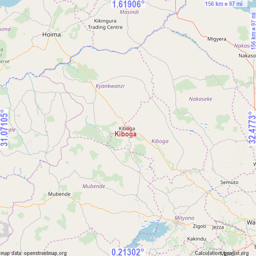
Kiboga GPS coordinates[2]
0° 54' 57.996" North, 31° 46' 27.012" East
| Map corner | latitude | longitude |
|---|---|---|
| Upper-left | 1.61906°, | 31.07105° |
| Center: | 0.91611°, | 31.77417° |
| Lower-right: | 0.21302°, | 32.4773° |
| Map W x H: | 156.3×156.3 km | = 97.1×97.1mi |
| max Lat: | 3.66088° ⇑44.5% North |
| Kiboga: | 0.91611° |
| min Lat: | ⇓55.5% South -1.28538° |
| min Long | Kiboga | max Long |
| 29.65° | 31.77417° | 34.95° |
| W 39%⇐ | ⇒61% E |
Elevation
Elevation of Kiboga is 1280 m = 4199 ft, and this is 21 m = 69 ft above average elevation for this country.
| Max E: |
4129 m = 13547 ft | 29.5% |
| Kiboga | 1280 m 4199 ft | |
| Avg. | 1259 m = 4131 ft | |
Min E: |
622 m = 2041 ft | 70.5% |
See also: Uganda elevation on elevation.city.
Geographical zone
Kiboga is located in North Torrid zone (between Equator and Tropic of Cancer). Distance of Equator is 101.9 km =63.3 mi to South.| Distance of | km | miles | from Kiboga |
|---|---|---|---|
| North Pole | 9905.2 | 6154.8 | to North |
| Arctic Circle | 7299.3 | 4535.6 | to North |
| Tropic Cancer | 2504.1 | 1556 | to North |
| Equator | 101.9 | 63.3 | to South |


Nearby cities:
15 places around Kiboga: (largest is in red/bold)
• Gombe
86.6 km =53.8 mi,  156°
156°
• Gombe
91.8 km =57 mi,  121°
121°
• Hoima
74.2 km =46.1 mi,  320°
320°
• Kakumiro
52.3 km =32.5 mi,  253°
253°
• Kanoni
83 km =51.6 mi,  171°
171°
• Kibale
79.7 km =49.5 mi,  260°
260°
• Kyankwanzi
31.8 km =19.8 mi,  5°
5°
• Luwero
78.1 km =48.5 mi,  95°
95°
• Masindi
84.6 km =52.6 mi,  355°
355°
• Mityana
61.9 km =38.5 mi,  153°
153°
• Mubende
58 km =36 mi,  226°
226°
• Nakaseke
70.3 km =43.7 mi,  105°
105°
• Nakasongola
87.5 km =54.4 mi,  60°
60°
• Namasuba
76.2 km =47.3 mi, 109°
• Wobulenzi
84.7 km =52.6 mi, 104°
Sources, notices
• [Note1] Compared only with cities in Uganda existing in our database
• [Src1] Map data: © OpenStreetMap contributors (CC-BY-SA)
• [Src2] Other city data from geonames.org with taken over terms of usage.
• [Src3] Geographical zone / Annual Mean Temperature by Robert A. Rohde @ Wikipedia
