Masindi geodata
Masindi (Western Region) is a seat of a second-order administrative division; located in Uganda in Africa/Kampala (GMT+3) time zone. With population of 31,486 people, there are 23 cities with bigger population in this country. Compared to other cities in Uganda, 74% of cities are located further ↓South; 63.7% of cities are located further →East and 61% of cities have higher elevation than Masindi. Note1
Administrative division(s):
- Level 1: Western Region
- Level 2: Masindi District
- Level 3: Masindi Municipality
- Level 4: Central Division


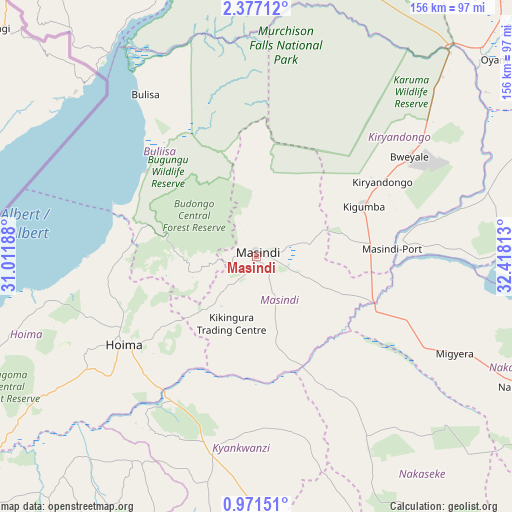
Masindi GPS coordinates[2]
1° 40' 27.984" North, 31° 42' 54" East
| Map corner | latitude | longitude |
|---|---|---|
| Upper-left | 2.37712°, | 31.01188° |
| Center: | 1.67444°, | 31.715° |
| Lower-right: | 0.97151°, | 32.41813° |
| Map W x H: | 156.3×156.3 km | = 97.1×97.1mi |
| max Lat: | 3.66088° ⇑26% North |
| Masindi: | 1.67444° |
| min Lat: | ⇓74% South -1.28538° |
| min Long | Masindi | max Long |
| 29.65° | 31.715° | 34.95° |
| W 36.3%⇐ | ⇒63.7% E |
Elevation
Elevation of Masindi is 1140 m = 3740 ft, and this is 119 m = 390 ft below average elevation for this country.
| Max E: |
4129 m = 13547 ft | 61% |
| Avg. | 1259 m = 4131 ft | |
| Masindi | 1140 m = 3740 ft | |
Min E: |
622 m = 2041 ft | 39% |
See also: Uganda elevation on elevation.city.
Geographical zone
Masindi is located in North Torrid zone (between Equator and Tropic of Cancer). Distance of Equator is 186.2 km =115.7 mi to South.| Distance of | km | miles | from Masindi |
|---|---|---|---|
| North Pole | 9820.9 | 6102.4 | to North |
| Arctic Circle | 7215 | 4483.2 | to North |
| Tropic Cancer | 2419.7 | 1503.5 | to North |
| Equator | 186.2 | 115.7 | to South |


Nearby cities:
15 places around Masindi: (largest is in red/bold)
• Apac
97.5 km =60.6 mi,  69°
69°
• Bulisa
59.7 km =37.1 mi,  325°
325°
• Hoima
48.4 km =30.1 mi,  236°
236°
• Kakumiro
108.5 km =67.4 mi,  203°
203°
• Kibale
121 km =75.2 mi,  216°
216°
• Kiboga
84.6 km =52.6 mi,  175°
175°
• Kigorobya
45.6 km =28.3 mi,  261°
261°
• Kiryandongo
44.6 km =27.7 mi,  59°
59°
• Kyankwanzi
53.5 km =33.2 mi,  169°
169°
• Masindi Port
41.3 km =25.7 mi,  86°
86°
• Nakasongola
91.9 km =57.1 mi,  116°
116°
• Nebbi
113.3 km =70.4 mi,  322°
322°
• Nwoya
111.4 km =69.2 mi,  16°
16°
• Oyam
97.1 km =60.3 mi,  50°
50°
• Paidha
115.7 km =71.9 mi, 315°
Sources, notices
• [Note1] Compared only with cities in Uganda existing in our database
• [Src1] Map data: © OpenStreetMap contributors (CC-BY-SA)
• [Src2] Other city data from geonames.org with taken over terms of usage.
• [Src3] Geographical zone / Annual Mean Temperature by Robert A. Rohde @ Wikipedia
