Kalangala geodata
Kalangala (Central Region) is a seat of a second-order administrative division; located in Uganda in Africa/Kampala (GMT+3) time zone. In our database, there are 80 cities with bigger population. Compared to other cities in Uganda, 83.6% of cities are located further ↑North; 54.1% of cities are located further →East and 59.6% of cities have lower elevation than Kalangala. Note1
Administrative division(s):
- Level 1: Central Region
- Level 2: Kalangala District
- Level 3: Bujjumba
- Level 4: Mugoye


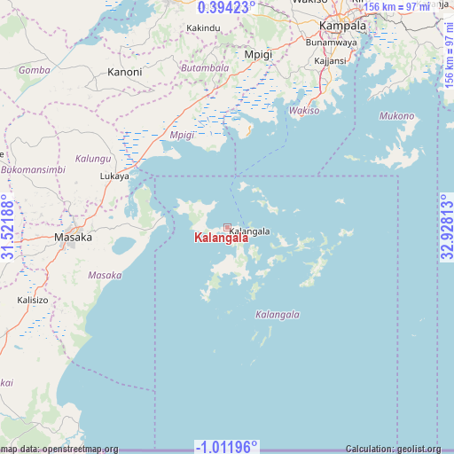
Kalangala GPS coordinates[2]
0° 18' 32.004" South, 32° 13' 30" East
| Map corner | latitude | longitude |
|---|---|---|
| Upper-left | 0.39423°, | 31.52188° |
| Center: | -0.30889°, | 32.225° |
| Lower-right: | -1.01196°, | 32.92813° |
| Map W x H: | 156.4×156.4 km | = 97.2×97.2mi |
| max Lat: | 3.66088° ⇑83.6% North |
| Kalangala: | -0.30889° |
| min Lat: | ⇓16.4% South -1.28538° |
| min Long | Kalangala | max Long |
| 29.65° | 32.225° | 34.95° |
| W 45.9%⇐ | ⇒54.1% E |
Elevation
Elevation of Kalangala is 1222 m = 4009 ft, and this is 37 m = 121 ft below average elevation for this country.
| Max E: |
4129 m = 13547 ft | 40.4% |
| Avg. | 1259 m = 4131 ft | |
| Kalangala | 1222 m = 4009 ft | |
Min E: |
622 m = 2041 ft | 59.6% |
See also: Uganda elevation on elevation.city.
Geographical zone
Kalangala is located in South Torrid zone (between Equator and Tropic of Capricorn). Distance of Equator is 34.3 km =21.3 mi to North.| Distance of | km | miles | from Kalangala |
|---|---|---|---|
| Equator | 34.3 | 21.3 | to North |
| Tropic Capricorn | 2571.6 | 1597.9 | to South |
| Antarctic Circle | 7366.8 | 4577.5 | to South |
| South Pole | 9972.7 | 6196.7 | to South |


Nearby cities:
15 places around Kalangala: (largest is in red/bold)
• Bukomansimbi
71 km =44.1 mi,  283°
283°
• Entebbe
49.5 km =30.8 mi,  34°
34°
• Gombe
59 km =36.7 mi,  345°
345°
• Kajansi
67.7 km =42.1 mi, 30°
• Kalungu
54.1 km =33.6 mi,  286°
286°
• Kampala
80.1 km =49.8 mi, 29°
• Kampala Central Division
80.5 km =50 mi, 28°
• Kanoni
66.2 km =41.1 mi,  324°
324°
• Kasaali
82.5 km =51.3 mi,  245°
245°
• Kyotera
85.7 km =53.3 mi, 246°
• Lweeza
70.2 km =43.6 mi, 34°
• Masaka
54.7 km =34 mi,  267°
267°
• Mityana
83.8 km =52.1 mi,  344°
344°
• Mpigi
60.2 km =37.4 mi,  9°
9°
• Wakiso
83.5 km =51.9 mi,  18°
18°
Sources, notices
• [Note1] Compared only with cities in Uganda existing in our database
• [Src1] Map data: © OpenStreetMap contributors (CC-BY-SA)
• [Src2] Other city data from geonames.org with taken over terms of usage.
• [Src3] Geographical zone / Annual Mean Temperature by Robert A. Rohde @ Wikipedia
