Ngora geodata
Ngora (Eastern Region) is a seat of a second-order administrative division; located in Uganda in Africa/Kampala (GMT+3) time zone. In our database, there are 80 cities with bigger population. Compared to other cities in Uganda, 69.9% of cities are located further ↓South; 82.9% of cities are located further ←West and 76.7% of cities have higher elevation than Ngora. Note1
Administrative division(s):
- Level 1: Eastern Region
- Level 2: Ngora District
- Level 3: Ngora County
- Level 4: Kobwin


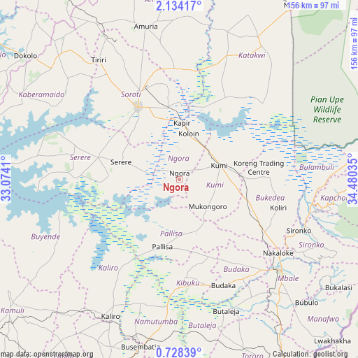
Ngora GPS coordinates[2]
1° 25' 53.004" North, 33° 46' 37.992" East
| Map corner | latitude | longitude |
|---|---|---|
| Upper-left | 2.13417°, | 33.0741° |
| Center: | 1.43139°, | 33.77722° |
| Lower-right: | 0.72839°, | 34.48035° |
| Map W x H: | 156.3×156.3 km | = 97.1×97.1mi |
| max Lat: | 3.66088° ⇑30.1% North |
| Ngora: | 1.43139° |
| min Lat: | ⇓69.9% South -1.28538° |
| min Long | Ngora | max Long |
| 29.65° | 33.77722° | 34.95° |
| W 82.9%⇐ | ⇒17.1% E |
Elevation
Elevation of Ngora is 1103 m = 3619 ft, and this is 156 m = 512 ft below average elevation for this country.
| Max E: |
4129 m = 13547 ft | 76.7% |
| Avg. | 1259 m = 4131 ft | |
| Ngora | 1103 m = 3619 ft | |
Min E: |
622 m = 2041 ft | 23.3% |
See also: Uganda elevation on elevation.city.
Geographical zone
Ngora is located in North Torrid zone (between Equator and Tropic of Cancer). Distance of Equator is 159.2 km =98.9 mi to South.| Distance of | km | miles | from Ngora |
|---|---|---|---|
| North Pole | 9847.9 | 6119.2 | to North |
| Arctic Circle | 7242 | 4500 | to North |
| Tropic Cancer | 2446.8 | 1520.4 | to North |
| Equator | 159.2 | 98.9 | to South |


Nearby cities:
15 places around Ngora: (largest is in red/bold)
• Amuria
65.2 km =40.5 mi,  347°
347°
• Budaka
50.3 km =31.3 mi,  160°
160°
• Bukedea
32.9 km =20.4 mi,  112°
112°
• Butaleja
60.9 km =37.8 mi, 161°
• Butebo
30.9 km =19.2 mi,  148°
148°
• Kaliro
67.2 km =41.8 mi,  207°
207°
• Katakwi
55.3 km =34.4 mi,  22°
22°
• Kibuku
43.2 km =26.8 mi,  177°
177°
• Kumi
18 km =11.2 mi,  79°
79°
• Mbale
58.9 km =36.6 mi,  131°
131°
• Namutumba
67 km =41.6 mi,  188°
188°
• Pallisa
32.7 km =20.3 mi, 193°
• Serere
36.5 km =22.7 mi,  281°
281°
• Sironko
56.8 km =35.3 mi, 113°
• Soroti
36.5 km =22.7 mi,  329°
329°
Sources, notices
• [Note1] Compared only with cities in Uganda existing in our database
• [Src1] Map data: © OpenStreetMap contributors (CC-BY-SA)
• [Src2] Other city data from geonames.org with taken over terms of usage.
• [Src3] Geographical zone / Annual Mean Temperature by Robert A. Rohde @ Wikipedia
