Katakwi geodata
Katakwi (Eastern Region) is a seat of a second-order administrative division; located in Uganda in Africa/Kampala (GMT+3) time zone. In our database, there are 80 cities with bigger population. Compared to other cities in Uganda, 77.4% of cities are located further ↓South; 87.7% of cities are located further ←West and 72.6% of cities have higher elevation than Katakwi. Note1
Administrative division(s):
- Level 1: Eastern Region
- Level 2: Katakwi District
- Level 3: Usuk
- Level 4: Katakwi


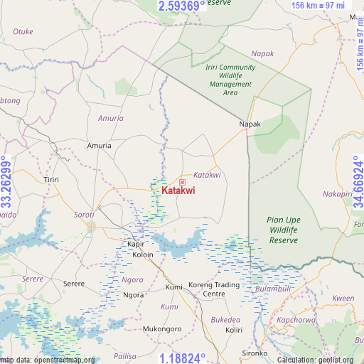
Katakwi GPS coordinates[2]
1° 53' 27.996" North, 33° 57' 57.996" East
| Map corner | latitude | longitude |
|---|---|---|
| Upper-left | 2.59369°, | 33.26299° |
| Center: | 1.89111°, | 33.96611° |
| Lower-right: | 1.18824°, | 34.66924° |
| Map W x H: | 156.3×156.3 km | = 97.1×97.1mi |
| max Lat: | 3.66088° ⇑22.6% North |
| Katakwi: | 1.89111° |
| min Lat: | ⇓77.4% South -1.28538° |
| min Long | Katakwi | max Long |
| 29.65° | 33.96611° | 34.95° |
| W 87.7%⇐ | ⇒12.3% E |
Elevation
Elevation of Katakwi is 1111 m = 3645 ft, and this is 148 m = 486 ft below average elevation for this country.
| Max E: |
4129 m = 13547 ft | 72.6% |
| Avg. | 1259 m = 4131 ft | |
| Katakwi | 1111 m = 3645 ft | |
Min E: |
622 m = 2041 ft | 27.4% |
See also: Uganda elevation on elevation.city.
Geographical zone
Katakwi is located in North Torrid zone (between Equator and Tropic of Cancer). Distance of Equator is 210.3 km =130.7 mi to South.| Distance of | km | miles | from Katakwi |
|---|---|---|---|
| North Pole | 9796.8 | 6087.4 | to North |
| Arctic Circle | 7190.9 | 4468.2 | to North |
| Tropic Cancer | 2395.6 | 1488.6 | to North |
| Equator | 210.3 | 130.7 | to South |


Nearby cities:
15 places around Katakwi: (largest is in red/bold)
• Alebtong
88.3 km =54.9 mi,  296°
296°
• Amuria
37.2 km =23.1 mi,  289°
289°
• Binyin
82.2 km =51.1 mi,  129°
129°
• Bukedea
64.5 km =40.1 mi,  171°
171°
• Butebo
77.6 km =48.2 mi,  183°
183°
• Dokolo
87.6 km =54.4 mi,  270°
270°
• Kapchorwa
76.6 km =47.6 mi,  135°
135°
• Kumi
48 km =29.8 mi, 183°
• Napak
51 km =31.7 mi,  38°
38°
• Ngora
55.3 km =34.4 mi,  202°
202°
• Otuke
85.2 km =52.9 mi,  322°
322°
• Pallisa
87.7 km =54.5 mi, 198°
• Serere
71.9 km =44.7 mi,  232°
232°
• Sironko
79.8 km =49.6 mi,  156°
156°
• Soroti
44.1 km =27.4 mi,  243°
243°
Sources, notices
• [Note1] Compared only with cities in Uganda existing in our database
• [Src1] Map data: © OpenStreetMap contributors (CC-BY-SA)
• [Src2] Other city data from geonames.org with taken over terms of usage.
• [Src3] Geographical zone / Annual Mean Temperature by Robert A. Rohde @ Wikipedia
