Pisgah geodata
Pisgah (Alabama) is a populated place; located in United States in America/Chicago (GMT-5) time zone. With population of 697 people, there are 18704 cities with bigger population in this country. Compared to other cities in United States, 88.6% of cities are located further ↑North; 52.6% of cities are located further ←West and 60.5% of cities have higher elevation than Pisgah. Note1


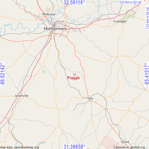
Pisgah GPS coordinates[2]
31° 59' 48.552" North, 86° 7' 5.844" West
| Map corner | latitude | longitude |
|---|---|---|
| Upper-left | 32.59118°, | -86.82142° |
| Center: | 31.99682°, | -86.11829° |
| Lower-right: | 31.39858°, | -85.41517° |
| Map W x H: | 132.6×132.6 km | = 82.4×82.4mi |
| max Lat: | 71.29058° ⇑88.6% North |
| Pisgah: | 31.99682° |
| min Lat: | ⇓11.4% South 19.06759° |
| min Long | Pisgah | max Long |
| -171.73463° | -86.11829° | -66.98998° |
| W 52.6%⇐ | ⇒47.4% E |
Elevation
Elevation of Pisgah is 152 m = 499 ft, and this is 142.8 m = 469 ft below average elevation for this country.
| Max E: |
3189 m = 10463 ft | 60.5% |
| Avg. | 294.8 m = 967 ft | |
| Pisgah | 152 m = 499 ft | |
Min E: |
-60 m = -197 ft | 39.5% |
See also: United States elevation on elevation.city.
Geographical zone
Pisgah is located in North temperate zone (between Tropic of Cancer and the Arctic Circle). Distance of this Northern Tropic circle is 951.8 km =591.4 mi to South.| Distance of | km | miles | from Pisgah |
|---|---|---|---|
| North Pole | 6449.3 | 4007.4 | to North |
| Arctic Circle | 3843.5 | 2388.2 | to North |
| Tropic Cancer | 951.8 | 591.4 | to South |
| Equator | 3557.7 | 2210.7 | to South |


Nearby cities:
15 places around Pisgah: (largest is in red/bold)
• Brantley
47.9 km =29.8 mi,  195°
195°
• Brundidge
42 km =26.1 mi,  137°
137°
• Emerald Mountain
50.2 km =31.2 mi,  2°
2°
• Fort Deposit
43.4 km =27 mi,  268°
268°
• Greenville
50.7 km =31.5 mi,  248°
248°
• Hayneville
48.2 km =30 mi,  295°
295°
• Inverness
35.2 km =21.9 mi,  86°
86°
• Joquin
23.8 km =14.8 mi,  190°
190°
• Luverne
34.1 km =21.2 mi, 203°
• Matthews
31.7 km =19.7 mi,  19°
19°
• Montgomery
44.6 km =27.7 mi,  337°
337°
• Pike Road
32 km =19.9 mi, 2°
• Taylor
11.1 km =6.9 mi,  257°
257°
• Troy
25.2 km =15.7 mi,  146°
146°
• Union Springs
41.4 km =25.7 mi,  66°
66°
Sources, notices
• [Note1] Compared only with cities in United States existing in our database
• [Src1] Map data: © OpenStreetMap contributors (CC-BY-SA)
• [Src2] Other city data from geonames.org with taken over terms of usage.
• [Src3] Geographical zone / Annual Mean Temperature by Robert A. Rohde @ Wikipedia
