Horn Lake geodata
Horn Lake (Mississippi) is a populated place; located in United States in America/Chicago (GMT-5) time zone. With population of 26,915 people, there are 1863 cities with bigger population in this country. Compared to other cities in United States, 75.6% of cities are located further ↑North; 59.1% of cities are located further →East and 72% of cities have higher elevation than Horn Lake. Note1


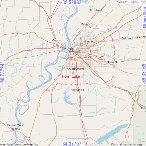
Horn Lake GPS coordinates[2]
34° 57' 19.332" North, 90° 2' 5.316" West
| Map corner | latitude | longitude |
|---|---|---|
| Upper-left | 35.52962°, | -90.73794° |
| Center: | 34.95537°, | -90.03481° |
| Lower-right: | 34.37707°, | -89.33169° |
| Map W x H: | 128.2×128.2 km | = 79.7×79.7mi |
| max Lat: | 71.29058° ⇑75.6% North |
| Horn Lake: | 34.95537° |
| min Lat: | ⇓24.4% South 19.06759° |
| min Long | Horn Lake | max Long |
| -171.73463° | -90.03481° | -66.98998° |
| W 40.9%⇐ | ⇒59.1% E |
Elevation
Elevation of Horn Lake is 89 m = 292 ft, and this is 205.8 m = 675 ft below average elevation for this country.
| Max E: |
3189 m = 10463 ft | 72% |
| Avg. | 294.8 m = 967 ft | |
| Horn Lake | 89 m = 292 ft | |
Min E: |
-60 m = -197 ft | 28% |
See also: United States elevation on elevation.city.
Geographical zone
Horn Lake is located in North temperate zone (between Tropic of Cancer and the Arctic Circle). Distance of this Northern Tropic circle is 1280.8 km =795.9 mi to South.| Distance of | km | miles | from Horn Lake |
|---|---|---|---|
| North Pole | 6120.4 | 3803 | to North |
| Arctic Circle | 3514.5 | 2183.8 | to North |
| Tropic Cancer | 1280.8 | 795.9 | to South |
| Equator | 3886.7 | 2415.1 | to South |


Nearby cities:
15 places around Horn Lake: (largest is in red/bold)
• Bartlett
31.3 km =19.4 mi,  27°
27°
• Byhalia
32.7 km =20.3 mi,  106°
106°
• Coldwater
29.8 km =18.5 mi,  169°
169°
• Collierville
35.1 km =21.8 mi,  74°
74°
• Germantown
25.1 km =15.6 mi,  54°
54°
• Hernando
15.1 km =9.4 mi, 165°
• Lynchburg
5.6 km =3.5 mi,  277°
277°
• Marion
32.4 km =20.1 mi,  332°
332°
• Memphis
21.6 km =13.4 mi,  356°
356°
• New South Memphis
14.7 km =9.1 mi,  352°
352°
• Olive Branch
18.7 km =11.6 mi,  87°
87°
• Southaven
4.3 km =2.7 mi, 28°
• Tunica Resorts
31.4 km =19.5 mi,  245°
245°
• Walls
10.7 km =6.6 mi,  271°
271°
• West Memphis
25.2 km =15.7 mi, 327°
Sources, notices
• [Note1] Compared only with cities in United States existing in our database
• [Src1] Map data: © OpenStreetMap contributors (CC-BY-SA)
• [Src2] Other city data from geonames.org with taken over terms of usage.
• [Src3] Geographical zone / Annual Mean Temperature by Robert A. Rohde @ Wikipedia
