West Memphis geodata
West Memphis (Arkansas) is a populated place; located in United States in America/Chicago (GMT-5) time zone. With population of 25,052 people, there are 1998 cities with bigger population in this country. Compared to other cities in United States, 74.6% of cities are located further ↑North; 59.6% of cities are located further →East and 76% of cities have higher elevation than West Memphis. Note1
Administrative division(s):
- Level 1: Arkansas
- Level 2: Crittenden County
- Level 3: Township of Mississippi


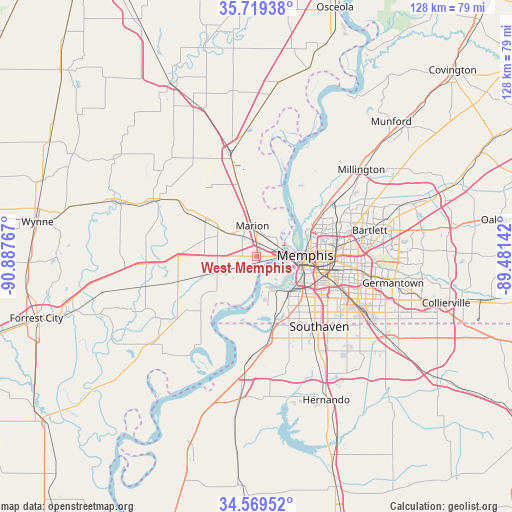
West Memphis GPS coordinates[2]
35° 8' 47.328" North, 90° 11' 4.344" West
| Map corner | latitude | longitude |
|---|---|---|
| Upper-left | 35.71938°, | -90.88767° |
| Center: | 35.14648°, | -90.18454° |
| Lower-right: | 34.56952°, | -89.48142° |
| Map W x H: | 127.9×127.9 km | = 79.5×79.5mi |
| max Lat: | 71.29058° ⇑74.6% North |
| West Memphis: | 35.14648° |
| min Lat: | ⇓25.4% South 19.06759° |
| min Long | West Memphis | max Long |
| -171.73463° | -90.18454° | -66.98998° |
| W 40.4%⇐ | ⇒59.6% E |
Elevation
Elevation of West Memphis is 66 m = 217 ft, and this is 228.8 m = 751 ft below average elevation for this country.
| Max E: |
3189 m = 10463 ft | 76% |
| Avg. | 294.8 m = 967 ft | |
| West Memphis | 66 m = 217 ft | |
Min E: |
-60 m = -197 ft | 24% |
See also: United States elevation on elevation.city.
Geographical zone
West Memphis is located in North temperate zone (between Tropic of Cancer and the Arctic Circle). Distance of this Northern Tropic circle is 1302 km =809 mi to South.| Distance of | km | miles | from West Memphis |
|---|---|---|---|
| North Pole | 6099.1 | 3789.8 | to North |
| Arctic Circle | 3493.3 | 2170.6 | to North |
| Tropic Cancer | 1302 | 809 | to South |
| Equator | 3907.9 | 2428.3 | to South |


Nearby cities:
15 places around West Memphis: (largest is in red/bold)
• Bartlett
29 km =18 mi,  77°
77°
• Earle
29.4 km =18.3 mi,  299°
299°
• Germantown
34.7 km =21.6 mi,  101°
101°
• Horn Lake
25.2 km =15.7 mi,  147°
147°
• Hughes
34.1 km =21.2 mi,  229°
229°
• Lynchburg
22 km =13.7 mi,  158°
158°
• Marion
7.6 km =4.7 mi,  351°
351°
• Memphis
12.3 km =7.6 mi,  88°
88°
• Millington
33.9 km =21.1 mi,  50°
50°
• New South Memphis
13.4 km =8.3 mi,  119°
119°
• Parkin
37.5 km =23.3 mi,  290°
290°
• Southaven
23.5 km =14.6 mi,  138°
138°
• Tunica Resorts
37.6 km =23.4 mi,  203°
203°
• Turrell
26.8 km =16.7 mi, 345°
• Walls
21.1 km =13.1 mi,  172°
172°
Sources, notices
• [Note1] Compared only with cities in United States existing in our database
• [Src1] Map data: © OpenStreetMap contributors (CC-BY-SA)
• [Src2] Other city data from geonames.org with taken over terms of usage.
• [Src3] Geographical zone / Annual Mean Temperature by Robert A. Rohde @ Wikipedia
