Turrell geodata
Turrell (Arkansas) is a populated place; located in United States in America/Chicago (GMT-5) time zone. With population of 575 people, there are 19968 cities with bigger population in this country. Compared to other cities in United States, 73.3% of cities are located further ↑North; 59.8% of cities are located further →East and 75.3% of cities have higher elevation than Turrell. Note1
Administrative division(s):
- Level 1: Arkansas
- Level 2: Crittenden County
- Level 3: Township of Fogleman


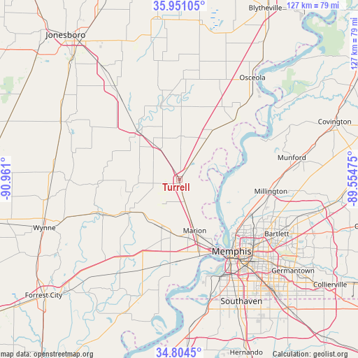
Turrell GPS coordinates[2]
35° 22' 47.316" North, 90° 15' 28.332" West
| Map corner | latitude | longitude |
|---|---|---|
| Upper-left | 35.95105°, | -90.961° |
| Center: | 35.37981°, | -90.25787° |
| Lower-right: | 34.8045°, | -89.55475° |
| Map W x H: | 127.5×127.5 km | = 79.2×79.2mi |
| max Lat: | 71.29058° ⇑73.3% North |
| Turrell: | 35.37981° |
| min Lat: | ⇓26.7% South 19.06759° |
| min Long | Turrell | max Long |
| -171.73463° | -90.25787° | -66.98998° |
| W 40.2%⇐ | ⇒59.8% E |
Elevation
Elevation of Turrell is 70 m = 230 ft, and this is 224.8 m = 738 ft below average elevation for this country.
| Max E: |
3189 m = 10463 ft | 75.3% |
| Avg. | 294.8 m = 967 ft | |
| Turrell | 70 m = 230 ft | |
Min E: |
-60 m = -197 ft | 24.7% |
See also: United States elevation on elevation.city.
Geographical zone
Turrell is located in North temperate zone (between Tropic of Cancer and the Arctic Circle). Distance of this Northern Tropic circle is 1327.9 km =825.1 mi to South.| Distance of | km | miles | from Turrell |
|---|---|---|---|
| North Pole | 6073.2 | 3773.7 | to North |
| Arctic Circle | 3467.3 | 2154.5 | to North |
| Tropic Cancer | 1327.9 | 825.1 | to South |
| Equator | 3933.9 | 2444.4 | to South |


Nearby cities:
15 places around Turrell: (largest is in red/bold)
• Bartlett
39.9 km =24.8 mi,  119°
119°
• Earle
22.2 km =13.8 mi,  238°
238°
• Joiner
17.4 km =10.8 mi,  35°
35°
• Keiser
35.8 km =22.2 mi,  23°
23°
• Lepanto
26.5 km =16.5 mi,  345°
345°
• Marion
19.2 km =11.9 mi,  163°
163°
• Marked Tree
22.5 km =14 mi,  319°
319°
• Memphis
31.9 km =19.8 mi,  143°
143°
• Millington
33 km =20.5 mi,  97°
97°
• New South Memphis
37.4 km =23.2 mi,  150°
150°
• Parkin
31.2 km =19.4 mi,  245°
245°
• Trumann
39.7 km =24.7 mi,  325°
325°
• Tyronza
15.3 km =9.5 mi, 323°
• West Memphis
26.8 km =16.7 mi,  165°
165°
• Wilson
28.6 km =17.8 mi, 43°
Sources, notices
• [Note1] Compared only with cities in United States existing in our database
• [Src1] Map data: © OpenStreetMap contributors (CC-BY-SA)
• [Src2] Other city data from geonames.org with taken over terms of usage.
• [Src3] Geographical zone / Annual Mean Temperature by Robert A. Rohde @ Wikipedia
